William Dargue A History of BIRMINGHAM Places & Placenames from A to Y
Marston Green, Marston Culy/ Marston Culey, Wavers Marston
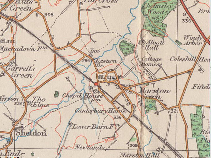
B37 - Grid reference SP168855
Merestone: first record in the Domesday Book 1086
There are many Marstons across the country. In Old English mersc tun means 'marsh farm'. To this has been added green, a term which which usually signified common grazing land. Marston Green lies between Hatchford Brook to the west and Low Brook to the east which both run northwards to join the River Cole. It also includes a swathe east of Low Brook, some of which remains as agricultural land. A large area south of the London-Birmingham railway has been taken up by Birmingham International Airport.
Listed as Merestone in the Domesday Book, this had been one of the many manors belonging to Earl Edwin of Mercia before the Norman Conquest. By 1086 it was in the hands of another Anglo-Saxon, Thorkell or Turchill of Warwick whose under-tenant was one Roger. The value of the manor in 1066 was 20 shillings. By 1086 the value had increased to 30s. This was unusual: because of the disruptions caused by the change of power at the Norman Conquest, many manors decreased in value over the subsequent 20 years. In Marston there were 4 villagers and 2 smallholders recorded, suggesting a population of perhaps 40 people at most. There was land for 3 ploughs and one for the lord's plough teams. There were 2 acres of meadow undoubtedly along the brooks.
The manor was divided into two parts in the 12th century. In order to distinguish between them the new manors took the name of their lords, Marston Culy and Wavers Marston.
Martson Culy - The de Culy family are first known in the area c1248 when Hugh de Culy held the manor. Ralph de Culy and his brother Walter held it in 1287 and in 1328 Katharine, possibly the widow of the former held it in 1328. Joan daughter of Hugh de Culy had married Richard de Whitacre. Their granddaughter Isabel was in the guardianship of Sir Fouk/ Fulk de Bermingham who held the manor until her marriage to his son Thomas de Bermingham. Their daughter, Elizabeth wife of Thomas Roche sold it to Hugh Freeman and Robert Leecrofte in 1399. In 1490 William Leecrofte died leaving the manor to his daughter Agnes, wife of John Lisle of Moxhull. Their son, Nicholas Lisle sold it to Reynold Digby of Coleshill whose descendants have since held it with Coleshill.
Marston Waver is not mentioned in the Domesday Book. The first lord of the manor may have been Anketill de Crafte in the 12th century. The manor passed to his nephew Sir Roger de Crafte, who sold it to William de Waver late that century. Hugh de Herdebergh seems to have been a sub-tenant. On the death of Earl Guy of Warwick in 1315 his heirs are mentioned and again in 1400. However, there is subsequently no further trace of this lordship.
William de Waver died c1230 and was succeeded by Robert whose son William obtained a charter of free warren in his demesne lands here and at Whitacre in 1257. This was the right purchase of the king to hunt freely on his lands; it was a status symbol for a manorial lord and an easy income for the king. On his death in 1271 he was succeeded by his son Robert. In 1427 John Waver sold the manor to John Catesby of Lapworth and it was in the hands of his grandson, also John Catesby in 1476. The manor descended through the Catesby family until 1574 when John Catesby sold it to Henry Maine. The manor then went through several changes of ownership and is last known held by Henry Godfrey Faussett in1820.
Marston Culy/ Marston Culey was known as Marston Green by 1830, but Marston Culey Farm was still shown on the 1891 Ordnance Survey map as a (medieval) moated site in the area now overlain by Farndon Avenue. It was presumably the site of the manor house. Another moated site, presumably the manor house of Wavers Marston, is shown south of Chelmsley Lane in the area where Wayside has now been laid out. Culey Place, perhaps its successor stands on the north side of Chelmsley Lane.
By the time of publication of the 1834 Ordnance Survey map Marston Green was tiny compact village around the junctions of Coleshill Road, Bickenhill Road, Elmdon Road, Chelmsley Lane and Holly Lane. Its preoccupations were entirely agricultural.
St Leonard's church
Chapel House Farm stood almost where the car park for Sheldon Country Park is now, off Elmdon Lane. The farmhouse was used as the clubhouse of Marston Green golf course after World War 2 and was demolished in the 1970s as part of the expansion of Birmingham Airport. The farmhouse is shown on the 1891 Ordnance Survey map as being built on the site of this first St Leonard’s church. Chapel House Farm is thought to have been of post-medieval origin dating perhaps from the 16th century. The church, then, must have been of medieval origin, probably a chapel of ease of St Peter's, Bickenhill.
The Digby family of Coleshill owned extensive tracts of land in this area. About 1860 Rev John Digby Wingfield Digby, the vicar of Coleshill, bought the disused non-conformist Marston Green chapel building (See below.) and had it refurbished as a private Anglican chapel. Albeit unconsecrated, local people were welcome to use it as a chapel of ease to save them the walk to the parish church at Bickenhill some three miles away. In 1920 Col F J B Wingfield Digby gave the chapel to the Diocese of Birmingham. It was renamed the Church of Saint Leonard in 1928 when Marston Green was taken out of the parish of Bickenhill and united with the parish of St Giles, Sheldon.

A new, much larger church dedicated to St Leonard was built nearby in Elmdon Road in 1938. It is a tall red-brown brick building in a basilica style, six bays long with tall round-arched windows, a chancel and side aisles and typical of its date. The old chapel continued to be used for meetings by various organisations, including the scouts and guides. It served as Marston Green Library Library until a new library was built; it was demolished in 1961.
The new church retained some mementos from the old chapel, including a church bench inside the entrance and a tablet in the memory of those killed in the First World War. The bell from the chapel was used at St Leonard’s until it was replaced in 1959.
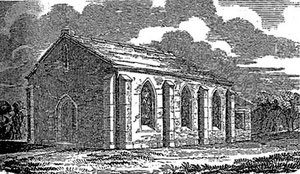
Marston Green Chapel
Ebenezer Congregationalist Chapel was a large church in Steelhouse Lane in Birmingham and was responsible for founding sometime before 1834 largely at their own expense daughter chapels at Coleshill, Knowle, Marston Green and Solihull. The Marston Green chapel, a simple building of three bays with Gothic windows, stood at east end of Station Road overlooking what is now the Memorial Garden, but which had been a water-filled disused gravel pit.

The chapel was dedicated in 1835 by Rev John Sibree, a Coventry Congregationalist who was very active in setting up mission churches. By the 1850s the numbers attending the mother church in town had halved to some 300 on a Sunday, and the mission at Marston Green had also fallen on hard times. A small congregation was unable to maintain the building which fell into disrepair. About 1860 the building was bought as an Anglican chapel (See above.)
The gravel pit was filled in and the triangular site between Station Road and Elmdon Road was laid out in 1949 as a Memorial Garden for those killed in the Second World War.
At the east end of the garden a small wall still remains from the old chapel. In 2011 a garden on the site of the chapel was refurbished and christened by Bickenhill Parish Council as the Chapel Garden.
The clock on the ‘village green’ is a relatively recent addition. Installed here in the Garden of Memory, it commemorates the Centenary of Bickenhill Parish Council and is dedicated to George Aston, a past chairman of the council. Sir Robert Taylor, then Lord Lieutenant of the West Midlands, and a former Managing Director of Birmingham Airport, arranged for the upkeep of the clock to be the responsibility of the airport and this remains the case today.

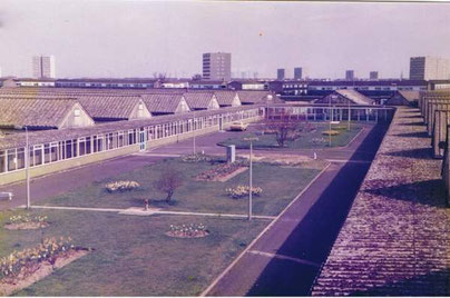
Marston Green Cottage Homes
In 1878 the Marston Green Cottage Homes were set up to take children of the poor out of the adult workhouse in Winson Green. Designed to take children from the age of 3 to 13 homes were laid out in a village-type arrangement in the countryside with 14 separate houses, each built to accommodate 30 children in the care of foster parents. There was a school, an infirmary, swimming bath, workshops, bakehouse and a house for the resident superintendent. A farm was built to the south of the homes to supply the institution with their own produce.
After 1911 two new cottages were built for infants under the age of two. A chapel was also built. The purpose of the homes was not just to care for children in a better environment than that of the workhouse. Children were given a basic education and were given training for employment. Boys learnt various practical trades, girls learnt housework and skill needed in service.
Image above: The Lodge on Coleshill Road. Almost out of sight behind the Photograph kindly supplied by Peter Higginbotham 'All Rights Reserved'; contact him for permission to reuse. See Acknowledgements for a link to his website, The Workhouse.

After 1930 the children’s homes were closed and the complex became Coleshill Mental Hospital (later Chelmsley Hospital). The children were either boarded with families or transferred to Aston Cottage Homes, Erdington or to Kings Norton Cottage Homes, Shenley Fields.
Chelmsley Hospital closed c1999 and many of the buildings were demolished.
Part of the site was built over with housing and the remainder was made into a Pinewood Business Park. The lodge, chapel and two of the cottages still survive, now as business premises.
Left: On Coleshill Road one of the later cottages to be built dated on the gable 1905. 'All Rights Reserved' Peter Higginbotham used with his kind permission.

The site of the homes is now built up with a housing estate around Brooklands Way and Maple Leaf Drive. Much of the farmland west of the cottages around Low Brook has been made into a Marston Green Park.
In 2006 Marston Green Park was designated as a nature reserve. It links Alcott Wood Nature Reserve, the Cole Valley and the Kingfisher Project and the green spaces around the National Exhibition Centre. As well as play areas for children, the park has a range of habitats ancient hedgerows, and species, including water voles on Low Brook, currently the fastest declining British mammal and the locally-rare Southern Marsh Orchid.
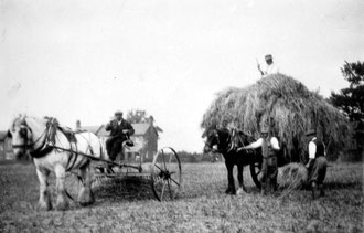
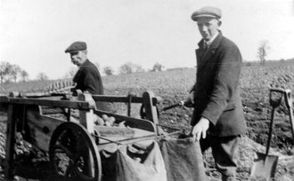
Below: The two photographs below and information are courtesy of Don Knibbs of the Knibbs Family website (See Acknowledgements). The photographs have been reproduced with the kind permission of Hilda Elliott, grand-daughter of Arthur Knibbs, known as Albert, seen working on the farm belonging to the Marston Green Cottage Homes in the 1920s. He is the one sitting on top of the hay cart and the older man on the hand-cranked potato grader.
Click to enlarge.

Marston Green Maternity Hospital
Early in the Second World War a base was built for the Royal Canadian Air Force off Berwicks Lane. Built as a series of huts, this was the 19th Canadian General Hospital with beds for some 700 patients.
In 1948 it became Marston Green Maternity Hospital, one of the first opened under the newly founded National Health Service. Hospital staff wore an enamel badge, the City of Birmingham coat-of-arms superimposed on a maple leaf, the symbol of Canada. By the 1960s the hospital had become the largest maternity unit in the country.
By the 1970s the huts had been connected by a series of enclosed corridors. Although the hospital never lay within the city, it was the birthplace of most children on the east side of Birmingham.
In the 1990s a new maternity unit was opened at East Birmingham Hospital (now Heartlands Hospital) and in 1999 Marston Green Maternity Hospital and the former Marston Green Cottage Homes, Chelmsley Hospital (Brooklands) were demolished. Housing has since been built on much of the site; part of it has been included in Marston Green Park.
Images of Marston Green Maternity Hospital c1980 by Derek Robinson/ degsy originally on the Birmingham History Forum and now on the History of Hospitals website. All Rights Reserved.
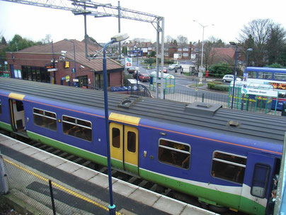
Marston Green Station
In 1838 the London-Birmingham railway opened passing very close to the village centre. Marston Green Station opened six years later. It was rebuilt in the 1970s not long after the London line was electrified.
Although the railway line opened up the district to Victorian commuters to Birmingham and some large houses were built as a result, it was not until some years after the First World War that house building began here in earnest.
Private houses were built along Elmdon Road, Elmdon Lane, Chelmsley Lane and Holly Lane. The busy shopping parade on Station Road dates from this time. In the 1970s, although Marston Green was effectively tacked on to the enormous housing development of Chelmsley Wood, it has still retained its identity as a village.
The expansion of Birmingham International Airport, first opened in 1939, has gradually taken up all the farmland south of the London railway line and efforts have been made to reduce the noise of aircraft by the erection of earth banks on the airfield boundary.
Images below:
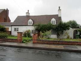
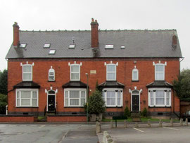
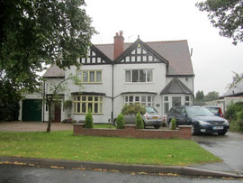
Left: A number of old cottages survive in Marston Green, this one on Elmdon Road. Centre: Prospect Villas are shown on the 1891 Ordnance Survey map, very first of the houses built to take advantage of the proximity to the railway station. Right: a house on Elmdon Lane typical of many in Marston Green.
William Dargue 06.04.2009/ 11.12.2020
For 19th-century Ordnance Survey maps of Birmingham go to British History Online.
Map below reproduced from Andrew Rowbottom’s website of Old Ordnance Survey maps Popular Edition, Birmingham 1921. Click the map to link to that website.