William Dargue A History of BIRMINGHAM Places & Placenames from A to Y
Moseley
formerly in Worcestershire - one of the Domesday manors of Birmingham
Moseley Village, Moseley in Yardley
B13 - Grid reference SP077831
Museleie: first record in the Domesday Book 1086

As for Moseley . . . it was a pretty little village in those days. The old village green, the rustic country inns (of which the "Fighting Cocks" was the chief), and some low-roofed, old-fashioned houses, backed by the parish church tower, made up a picture which still remains in my mind's eye.
The railway tunnel which is now looked upon as only a long bridge, was then regarded as something large in its way, and, perhaps, slightly dangerous, almost justifying a little something strong to sustain courage when travelling through it.
Beyond Moseley Church was a pretty road to Moseley Wake Green, in which were, if I remember rightly, one or two timbered houses and some old-fashioned residences, surrounded by high trees.
Many of these have now disappeared. In another direction from the church was a country road running to Sparkbrook, and near which were an important house and lands belonging to the wealthy Misses
Anderton, whose possessions have been heard of in more recent days.
I now often visit Moseley, and change, but not decay, in all around I see.

The prevailing colour of the old village green is now red brick, and the modern colour does not agree so well with my vision as the more rustic tones of a bygone day; whilst the noise and bustle of tram cars, the swarms of suburban residents that emerge from the railway station (especially at certain times in the day), are fast wiping out the peaceful, pretty Moseley of my youthful days.
These new old villages often present some curious anachronisms. A grey old church, partly buried by a hoary fat churchyard, is surrounded by the most modern of shops and stores; and a primitive little bow-windowed cottage, with a few flower pots in the window, has, perchance, a glaring gin shop next door.
Thomas Anderton writing in 1900 of his youth in
A Tale of One City: the New Birmingham

Although the King was both tenant-in-chief and lord of the manor of Kings Norton of which Moseley was part, Moseley was referred to as a manor from at least 1456. It was also one of the tax yields of the manor of Kings Norton. Moseley had its own manorial lord and manor house, which has stood on a number of sites in the village over the years.
It is thought that a medieval hall stood on the site King Edwards Road and that this was replaced by what was later referred to as Old Moseley Hall on the opposite side of the Alcester Road.
It is hard now to imagine Moseley village as anything other than the crossroads of the Alcester Road with St Marys Row and Salisbury Road. However, while the former roads date back over a thousand years or more, the name of Salisbury Road gives a clue as to its more recent creation. It was cut in 1896 and named after Lord Salisbury, Conservative Prime Minister on three occasions 1885-1886, 1886-1892 and 1895-1902. There is every reason to believe that the former T-junction here was the Saxon settlement site of mus leah whose name seems to mean 'fieldmouse clearing'. However, fieldmice were surely to be found in any field where cereal crops were grown, so this placename could be an Anglo-Saxon joke. It probably signified a small clearing.
Moseley was a northerly Saxon settlement in the Kingdom of the Hwicce, much of which was later to become Worcestershire. Amidst a sea of heavy red clay, it lay on an island of lighter glacial
drift, land with less dense tree cover and easier to plough. Listed in the Domesday Book with Kings Norton, Lindsworth, Rednal and Wythall as one of a number of berewicks of Bromsgrove, it was
later treated as a sub-manor of Kings Norton.

Moseley was a northerly Saxon settlement in the Kingdom of the Hwicce, much of which was later to become Worcestershire. Amidst a sea of heavy red clay, it lay on an island of lighter glacial drift, land with less dense tree cover and easier to plough. Listed in the Domesday Book with Kings Norton, Lindsworth, Rednal and Wythall as one of a number of berewicks of Bromsgrove, it was later treated as a sub-manor of Kings Norton.
Moseley Hall

In the 16th century the manor came into the possession of the Grevis/ Greaves family who also held neighbouring Yardley. In the late 16th-century they replaced the old hall with a new manor house on a site between Salisbury Road and Chantry Road.
A gate off the Alcester Road into Moseley Private Park now marks the entrance to the timber-framed hall. Used from the mid-17th century as a farmhouse, it survived until c1842. It was very likely a moated site.
In 1632 a new grander hall in neo-classical style was built on the site of the present Moseley Hall off the Alcester Road, south of Salisbury Road (not then in existence). Its builder was probably Sir Richard Greaves, a wealthy local landlord, High Sheriff of Worcester, Deputy-Lieutenant of Wales and a local magistrate knighted by King James I. His elaborate tomb can be seen in Kings Norton church.
After the financial decline of the Greaves family, button magnate, John Taylor I of Bordesley Hall bought the estate for his son John Taylor II, who proceeded to rebuild on the site. The new hall
was surrounded by a large walled park, landscaped by Humphrey Repton and approached by a long drive. Flanked on either side by a lodge, ornamental entrance gates hung between stone pillars
opposite the Fighting Cocks public house. This hall was severely damaged by fire in the 1791 Birmingham Riots..

Take a look at the 'new' Moseley Hall.
The hall was rebuilt in 1796, but altered and extended from the previous plan to roughly its present form. The cellars underneath the old building were retained and are thus the oldest part of
the present house. The hall then continued as the seat of the Taylor family until it was bought by Richard Cadbury in 1884.
Subsequent to his removal in 1892, Cadbury gave the hall to the City as a children's convalescent home, after which much of the parkland was sold for high-quality housing. The hall reopened in 1970 as a geriatric hospital. Though much extended in the 20th century and with many additions on the site, the original hall block is a Grade II Listed building.
Moseley Pool
The laying out of Salisbury Road in 1896 cut Moseley Hall's park in two. At that time it seemed likely that the remaining parkland and the pool would be built over. To prevent this, nine local businessmen and residents formed the Moseley Park and Pool Estate Company and leased 14 acres around the pool between Salisbury Road and Chantry Road.
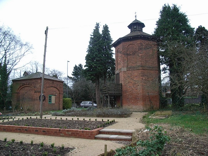
The pool was cleaned, a new park laid out, and the shareholders built their own houses backing onto it. In 1899 the local MP, Austin Chamberlain officially opened the park which remains a members' private park to this day. An interesting survival is the 18th-century ice-house in the park. This had been used for storage by the Chantry Tennis Club, but has lately been restored and is opened on occasions to the public.

Take a look at Moseley Dovecote.
On the Alcester Road close to Moseley Hall are the Moseley Dovecote and Cow House. Built in the 18th-century they are the last remnants of South Lodge, one of Moseley Hall's farms which was
demolished in 1937. These buildings, latterly used as pigsties, were saved thanks to local public pressure and finally restored in 1981. The dovecote is a red-brick octagonal building of three
storeys and is opened on occasions to the public. (See also Pigeon House Hill.)
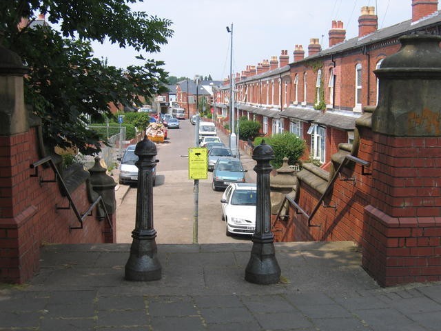
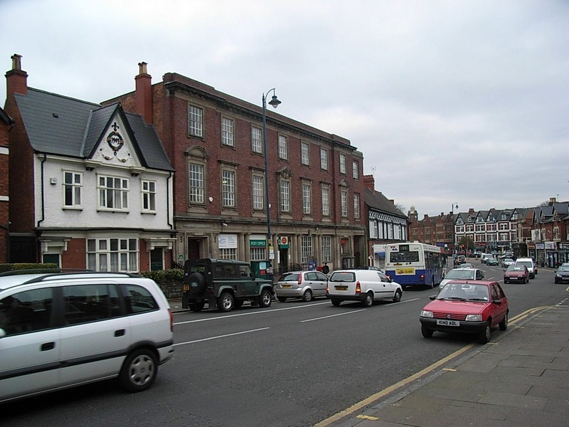
Moseley village
Moseley had a small village centre from the Middle Ages boasting two pubs and a smithy. Most of its small population was involved in agriculture and the Hall was a major employer whether in service or in the fields. By the 1850s the area began to attract a number of wealthy Birmingham business people who built elegant country houses in large estates. They were only thirty minutes from Birmingham along the Alcester/ Moseley Road but well out of the crowded smoky town. A regular horse-bus service ran from Birmingham from c1860 making the district accessible the middle class, and in 1867 Moseley station opened on the Birmingham & Gloucester line with a very frequent service. This prompted piecemeal building in Moseley initially along Woodbridge Road and further opened up the district to become a middle-class suburb.
Mosley, a chapelry in the parish of King's-Norton, upper division of the hundred of Halfshire, county Worcester, 2 miles South of Birmingham. It is a station on the Bristol and Birmingham
section of the Midland railway. The village, which is considerable, is a suburb of Birmingham. It formerly belonged to the Greveses, a family which came over at the Conquest. The living is a
perpetual curacy in the diocese of Worcester, value £160, in the patronage of the Vicar of Bromsgrove. The church, dedicated to St. Mary, was enlarged in 1822. There are National and other
schools. Moseley Hall is the principal residence.
The National Gazetteer of Great Britain and Ireland 1868
By 1890 housing had spread from Balsall Heath to Moseley along the Alcester Road with some very fine houses many of which remain. Moseley was joined by urban development to Birmingham, but not to
Kings Heath until the beginning of the 20th century. The district is referred to as Moseley while the centre retains its name as Moseley Village.
During the last quarter of the 20th century Moseley developed a reputation as Birmingham's Bohemian quarter. This may be due to the fact that many of the large Victorian houses became unviable
for family use and were turned into flats and bed-sits which attracted a student population. When they became employed some stayed on to buy and restore the old buildings. There is consequently a
wide social mix in the district and a village centre with a variety of restaurants, pubs and music venues as well as some interesting small shops. There is also an annual Moseley Festival which
includes a street fair and a folk festival which is held in Moseley Park.

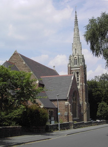
Well worth a visit - St Mary's Church.
Moseley's parish church was founded rather later than Birmingham's other ancient churches. St Mary's is first mentioned in 1405 in a letter of Pope Innocent VII which gave the Bishop of Worcester permission to licence the building for worship. The Pope was responding to a petition from local residents who wanted to save themselves the long journey to Kings Norton. At that time the route ran via Dogpool Lane across the wide marshy valley of the River Rea, which was prone to flooding in winter. (At that time Kings Norton itself was not an ecclesiastical parish but a chapel of ease of Bromsgrove.)
The oldest surviving part of the building is the tower which was built in 1514 using forty-eight wagon-loads of stone reused from Bromsgrove's old parsonage. Thomas Habington writing in his Survey of Worcestershire in the 1630s gives the information from an old book he had seen:
The steeple of Moseley was begun to be buylded 5 Hen[ry]. 8 An. Do. 1513. The chapel is dedicated to our Blessed Lady by John Wednesbury, Prior of Worcester , at the instant labor of John Middlemore of Haselwell, Sir William Bownell, Chaplayne to our Lady at Moseley, Humfrey Rotton, Thomas Greene, William Hawkes and John Moore gaue the stone walls of the parsonage of Bromesgrove, being xlviii [48] loades, towardes the buildinge of this Steeple. It appearethe also in the sayde booke that theare weare repayres done about the sayde chapel, and bells bought, tempore [in the time of] Hen. 8.
By 1780 the chapel had fallen into such disrepair that services could no longer be held here. The fallen roof was repaired and the church was encased in brick with fashionable round-headed windows in neo-classical style. But only forty years later, fashions had changed and the leading gothicist, Thomas Rickman was employed to remove the alterations and regothicise the church. He plastered the external brick-clad walls to look like stone, added cast-iron girders simulated as timber and put gothic-style iron frames in the windows.
Another forty years on and all of Rickman's work was lost in further gothic restoration. In 1876 the Birmingham architect, J A Chatwin restored, rebuilt and extended the building. Ten years later
a north aisle was added, and in 1897 the chancel and transept were built, bringing the church to its present size. The nave and south aisle were reconstructed in 1910 by Chatwin's son, P B
Chatwin who later also repaired the German bomb damage which occurred in 1940 during the Second World War.
Unusual bells
St Mary's had a unique ring of steel bells which attracted visiting ringers from all over the country. The peal originated in Sheffield. In a pioneering venture in 1861, eight steel bells cast by a Sheffield foundry were loaned to St Marie's Roman Catholic Church. This was an unusual experiment as English bells have been made from time immemorial with a copper-tin alloy known as bell metal. In comparison with bell metal, steel bells are very heavy for the note they produce. The steel bells were bought for St Mary's in 1874 by Sir John Holder of Pitmaston, Moor Green.
However, when the church was partially rebuilt in 1910, the ringing room floor was removed and the bells could no longer be rung full circle, only chimed with hammers. Examination in 1979 found the bell installation to be unsafe and it was recommended that it should be removed. However, a suggestion was made to the Parochial Church Council that the bells could and should be restored, these being now the only surviving steel bells in the country. After a great deal of fund-raising and 5000 hours of volunteer labour, the restoration was completed by Easter 1991, when the bells were rung after morning service for the first time in over 80 years.
The steel bells proved to be so difficult to ring and so unharmonious that in 2012 a new ring of 10 bells made in the traditional way by Taylor's of Loughborough was installed.

Take a look at the area around Park Hill
and St Anne's Church.
Developed from 1860s this district was built up with substantial middle-class houses most of which survive. The need for a church which reflected this affluent community was met by the building
of St Anne's paid for by wealthy local landowner Rebecca Anderton on land given by W F Taylor of Moseley Hall. Built in gothic style, the church was consecrated in 1874.
The building was badly damaged by a German bomb in 1940 and for a number of years services were held in the parish hall. Further damage was caused by storms. By 1948 the church had been repaired
and was reconsecrated.
Although all of the original stained glass windows were destroyed in the bombing, some has been replaced over the years. One of the new windows is by L C Evetts, which was installed in 1967, takes as its theme the sanctification of work. A silver chalice is the central feature and represents Birmingham's metal industries. On the pedestal of the chalice are silversmith's tools. The Birmingham hallmarks, the anchor and the lion are also Christian symbols: the anchor standing for hope and steadfastness, the lion for the resurrection of Christ.
Rebecca Anderton bought the three old 16th-century bells of St Mary's for the new church. A fourth, cast by James Barwell of Birmingham, was given by Miss Anderton in 1874, and an Ellacombe
chiming apparatus operated from the church porch was the gift of Mr F Elkington of Moseley Hall. The bells were restored in 2000 and a new tenor bell was added. Unusually, the peal of five are
not rung full circle, but may be chimed manually by ropes or electrically.
Oxford Road Baptist Church
Designed by J P Osborne of Birmingham in 1888 this church was the result of a design entered in the competition to build St Agnes Church at the other end of Oxford Road. Although it did not win,
it was considered of such high merit that the plans were bought for their use by the Baptists. The building is faced in pink sandstone, is in gothic decorated style and built in a cruciform
shape. There is a good polychromatic encaustic-tiled chancel floor, a marble immersion font, and stained glass of 1932 by A J Davis of the Bromsgrove Guild. The church is now a Calvary
Church of God.

Take a look at St Agnes' Church.
Suburban Moseley continued to expand beyond its original Kings Norton boundaries into the manor of Yardley. This was referred to at the time as Moseley in Yardley. (See also Wake Green.)
It was for this district that St Agnes' Church was built. The original wooden building which stood at the junction of Oxford Road and School Road still survives as a church hall at St Mary & St Ambrose Church on the Pershore Road near Edgbaston cricket ground.
The present church in St Agnes Road was the winning entry by William Davis in a competition. Designed in early decorated style it was intended to be built in three stages as finance allowed.

The chancel, transepts and part of the nave were built by 1884, the rest of the nave and aisles by 1893, and the tower completed in 1932.
There is good stained glass here, work in the south aisle by Hardma’s of Birmingham 1952 and further windows in the south aisle, south transept and the north aisle by Birmingham glass maker, Claude Price 1949-55.
This Grade II Listed building stands within the St Agnes Conservation Area of late 19th- and early 20th-century upper-middle-class housing much of it in Arts & Crafts style.

Take a look at Moseley village.
Moseley village centre is also conservation area and includes a number of Listed buildings such as Fivelands, a plain Georgian-style house of 1835 set back from the Alcester Road with a sweeping
carriage drive. Its name derives from the enclosed field on which it was built; this had created by the enclosure of five strips of one of the medieval open open fields of Moseley.
The Fighting Cocks public house, formerly the Fox and Dogs, was built for the Holte Brewery in 1899 to replace the Red Lion which had stood just north of the original site. It
was so-named after the practice of cock-fighting which was carried on here during the 18th century. King Edwards Road was built on the site of the old pub's bowling green and tea gardens. The
Fighting Cocks retains a good interior with walnut panelling and tiled murals depicting local scenes.
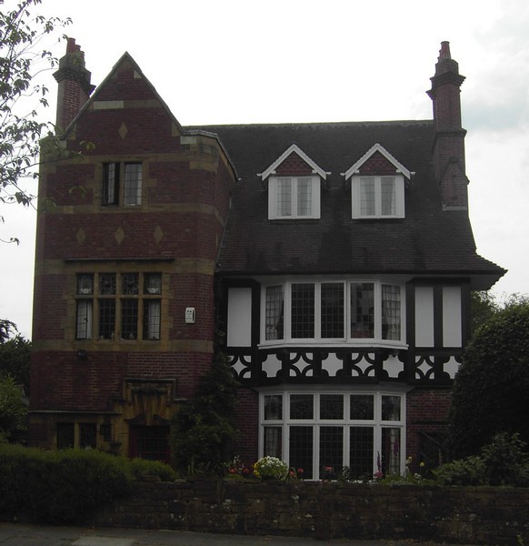
There are also good houses in Salisbury Road and in Amesbury Road, including Glengarriff, a splendid large Art & Crafts house of 1897 with a crenellated entrance tower and timber-framing on
the first floor.

The development of Moseley as a suburb was little affected by the Birmingham and Gloucester Railway until the building of Moseley Station. Kings Heath station, opened in 1840 with the line, was called Moseley station until 1867 when Moseley Station proper was opened. This closed in 1941, although buildings survived until the 1970s. Woodbridge Road is named after the wooden road bridge over the railway which lasted till 1908.
Although this was not the first railway line to open, the 150m long Moseley Tunnel was the first part of a railway to be built in Birmingham. The sand and gravel excavated here was used to build up the Balsall Heath embankment. Although the parliamentary authorisation had specified a tunnel to protect St Mary's Church from vibration and noise, the directors pressed ahead with a cutting which was less expensive.
Local people took the case to the Court of Chancery and the company were compelled to fill in the cutting as a tunnel; it is believed to be the first railway tunnel made in this way. The railway leaves Moseley under the Queens Bridge on the Alcester Road named in honour of Victoria's accession in 1837. It is proposed to reopen the station in 2021.

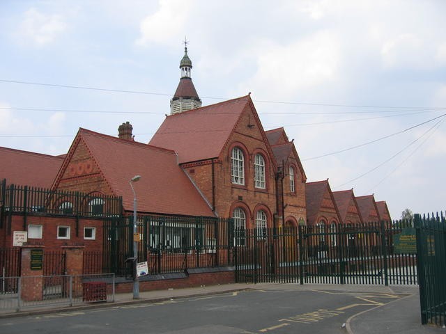
King David's School on the Alcester Road is unique as the only voluntary aided Jewish school in Birmingham. Education for Jewish children in Birmingham first took place at Singers Hill on Blucher Street until the Hebrew National School was built in Hurst Street in 1843. In 1856 the school moved to a new building at the corner of Ellis Street and Singers Hill where it remained until a larger school was built in St Lukes Road in 1932.
With the wholesale redevelopment during the 1950s and early 1960s of the Jewish quarter and the dispersal of Jewish families, the school moved to Moseley in 1965 as the King David Primary School.
By this time the Central Synagogue had moved to its new building on the Pershore Road, and the New Synagogue had moved to Park Road, Moseley.

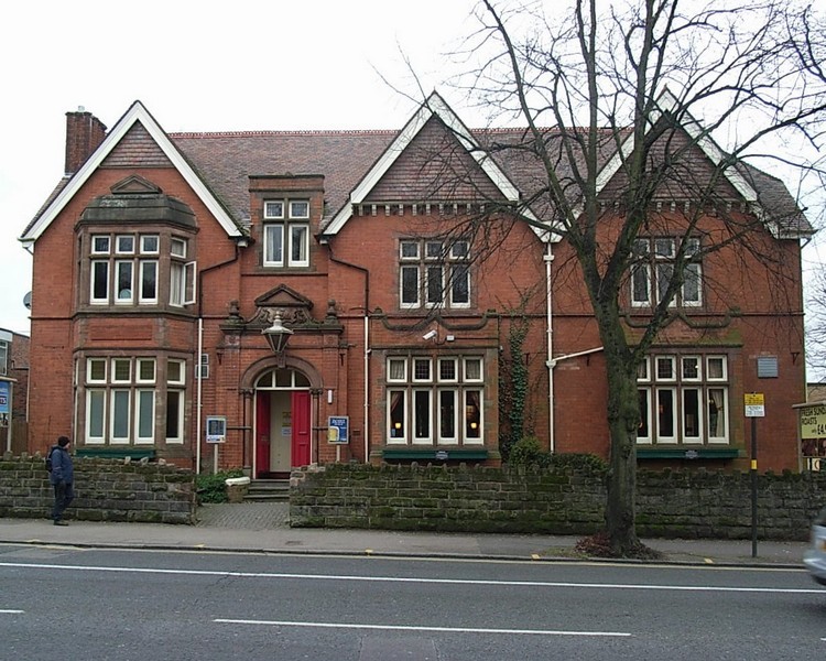
Take a look. On the Moseley Road near Brighton Road, on the border with Balsall Heath, stands the Moseley & Balsall Heath Institute.
Designed in Victorian gothic by local architect William Hale, it was built by local builder John Bowen in 1879. This was the home of a self-help organisation to improve the educational lot of poorer Victorians determined to better themselves. The institute was able to attract luminaries such as Charles Dickens and Oscar Wilde to lecture there.
A sculpture over the entrance represents Industry and Art depicting a blacksmith, metalworker and spinner flanked by the busts of Michaelangelo and Shakespeare. The tympana of the ground-floor windows show medieval figures engaged in art, drama, literature, music, poetry, science.

Laburnum Grove is a grove of fourteen houses formed by two rows of terraces facing onto a central path. There is no road. The Grove is within the Moseley Conservation Area.
Character Appraisal of Moseley Conservation Area: written for the City Council after designation in 1983
Laburnum Grove is a quiet cul de sac situated off Woodbridge Road. Each house is double fronted and one room deep with arches above openings. The houses were built c1850 as railway workers' cottages. Number 14 is the largest in the grove and was built for the stationmaster. Laburnum Grove was refurbished under an Urban Renewal Scheme in the 1970s with new chimneys, artificial slate roofs, imitation sash windows, front doors, brick paving and elegant timber fencing and gates.
This and other photographs of Moseley are the © copyright of Brendan Patchell and available on the Geograph website OS reference SP0783. They are reusable under Creative Commons Licence Attribution-Share Alike 2.0 Generic.
For a History of Laburnum Grove by Brendan Patchell click here.


William Dargue 07.04.2009/ 12.12 2020
For 19th-century Ordnance Survey maps of Birmingham go to British History Online.
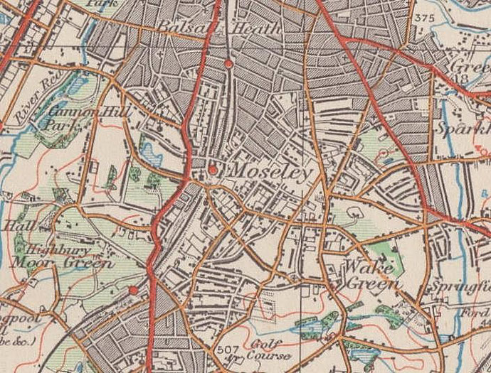
Map below reproduced from Andrew Rowbottom’s website of Old Ordnance Survey maps Popular Edition, Birmingham 1921. Click the map to link to that website.