

William Dargue A History of BIRMINGHAM Places & Placenames from A to Y
Moor Green, Moseley
B13 - Grid reference SP065824
de Mora, super Moram: first record 1275

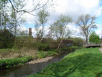
Moor Green is a small area with a number of archaeological finds of various periods, some of which have been discovered by virtue of the fact that Highbury Park has never been built over. Although untypical in the larger number of finds, it represents sites typical of the Birmingham area. Two burnt mounds of the Bronze Age have been excavated near the stream south of the lake in Highbury Park, one on the south bank with exposed burnt pebbles. Charcoal from these mounds has been radiocarbon-dated to c1025 BC. Their use is not certain, but the current thinking is that they served as saunas, possibly of a religious nature.
From the Roman period a coin of Antoninus Pius (138-161 AD) was found in 1977 with metal detector. An unusual find in the park is a 3rd-century Roman boundary stone with an inscription. The type of stone is peculiar to the Mediterranean region and is thought to have been brought here, and presumably lost, by an 18th-century antiquarian. It is now in Birmingham Museum.
The name Moor Green may be Anglo-Saxon or medieval and has its origin in mor green meaning 'common pasture by the marsh'. The marsh would have been at the bottom of the lane along the River Rea and the green itself was at the junction of Moor Green Lane and Shutlock Lane. The name is used as a locative surname by a number of individuals mentioned in the Northfield Subsidy Rolls of 1275.
Moor Green Forge was built in Tudor times. Also known as Farmons Mill, it stood on the River Rea near Holders Lane, and was first recorded in 1597. By the 1800s this was a blade mill and later operated as a rolling mill until c1880.

Another visible medieval feature is ridge and furrow in Highbury Park near Moor Green Lane. Lying between the stream and the railway, these are the remains of the strips of Moseley's open fields.
The locations of the open fields are unknown because they were enclosed early, before the spate of the parliamentary enclosures of the Georgian period.
The old road from Birmingham to Kings Norton used to cut through Moor Green. It followed the Moseley and Alcester roads from the town via Moor Green Lane and forded the river at Dogpool
Lane.
In the late Georgian period one of the last turnpikes to be set up in Birmingham was the Pershore Turnpike which opened to traffic in 1825. Largely a new route, it left Birmingham via Sherlock Street and the Pershore Road by-passing Balsall Heath, Moseley and Moor Green.
Another through-route was the Birmingham and Gloucester Railway, one of Birmingham's early railways, which cut through Highbury Park in 1840. A notable building here is Joseph Chamberlain's Highbury in Yew Tree Road, much of whose grounds were taken over as Highbury Park by the City Council in the 20th century. See Highbury.
The Pitmaston estate lies within Russell Road, Goodby Road, Holders Lane and Moor Green Lane. Most of the landscaping dates from 1870 when the original Pitmaston House was built to replace Moor Green Cottage for the wealthy Holder family, millers, brewers and distillers.
Woodland was created on an exposure of the Birmingham sandstone ridge with walkways carved into the outcrop. The Holders were miniature railway enthusiasts and built a 10¼ inch gauge track around the grounds of the house in 1898.
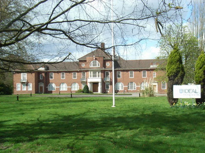
Also known as Pitmaston, the Ideal Benefit Society offices, which stand on the site of the original house, were designed in a neo-Gergian style by Birmingham architect, Holland W Hobbis in the 1930s. The building was Listed in 2003 and included in the Moseley Conservation Area the following year. In 2007 the company sold Pitmaston which is now private apartments.

Moor Green Hall, stood on Moor Green Lane opposite Yew Tree Road. It was the home of Arthur Chamberlain, brother of Joseph Chamberlain. The house was used by the Red Cross during the First World War as a military hospital. The north end of Elizabeth Road now runs on the site of the hall.
The New York Times reported an incident at the hall of the previous day in its edition of 13 February 1914:
Birmingham, 12th. A tube charged with high explosives was found to-day on a window sill of Moor Green Hall, Highbury, near here, the residence of Arthur Chamberlain, brother of the Right Hon. Joseph Chamberlain.
A fuse attached to the bomb was connected with a photographer's lamp in which a candle had been burning. The flame, however, was extinguished before it reached the fuse. A postcard addressed to Reginald McKenna, the Home secretary, was found near by. It bore the words, "Militancy is not dead., but if you are not already you soon will be." A quantity of suffrage literature was left nearby.
In 1914 Joseph had been long out of politics through ill health, while Arthur was chairman of Kynoch's making weapons.
Moor Green House, the home of Sir John Holder's son, stood on the east side of Moor Green Lane just before its junction with Yew Tree Road. During the First World War it was used as a hostel for Belgian refugees and then as a military hospital. It was demolished in 1920 and the Britannic Assurance office block was built in the grounds. This has recently been converted into luxury private flats. Boundary Drive stands roughly on the site of the original house.
Moor Green Lane was largely developed with good middle-class housing in the early 20th century, although The Firs c1886, Heatherdene 1891 and Englefield c1898 are late 19th-century. Houses here were built on plots sold separately and individually designed by various architects. Building was complete by the 1920s.
Click to enlarge the images below.


William Dargue 07.04.2009 / 02.01.2010
For 19th-century Ordnance Survey maps of Birmingham go to British History Online.
Map below reproduced from Andrew Rowbottom’s website of Old Ordnance Survey maps Popular Edition, Birmingham 1921. Click the map to link to that website.
