William Dargue A History of BIRMINGHAM Places & Placenames from A to Y
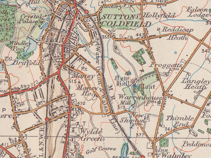
Maney, Maney Corner, Maney Hill
B72 - Grid reference SP118953
First record 1285

Maney is a middle-class district immediately south-east of Sutton town centre. It lies between Birmingham Road, the ancient route to Lichfield from the south-west, and the valley of the Plantsbrook.
The hamlet of Maney is shown on early Victorian maps around the junction of Birmingham Road and Manor Hill, but the origin of the name may lie further to the east in the river valley.
The second element of this Anglo-Saxon placename, eg, means 'well-watered land'. Plantsbrook or Ebrook (East Brook) flows south from Sutton Park.
The stream was dammed at Mill Street in the Middle Ages to provide water power for the manorial corn mill. It is now culverted under the town centre but reappears at Upper Holland Road. This is surely the source of the well-watered land. The first element may be an Anglo-Saxon personal name, Manna, or it may derive from maene eg meaning 'common' well-watered land. This would have been fertile pastureland over which local people would have had grazing rights.
Maney Hill rises south of Maney. It was here during the 20th century, especially after the Second World War, that middle-class housing defined the district.
Windmills were significant landmarks in the Middle Ages. At this time a peasant's hut was built low enough to touch the roof, the lord's house may have had two storeys and the church may not have
boasted a tower. But standing tall and high on Monkseaton Road was Maney Mill. Documented in 1309, it is Birmingham's earliest record of a windmill and is believed to have belonged to the manor
house.
The first wind-driven cornmills in England were built in the 12th century. The earliest were post mills and consisted of a movable wooden structure holding both the sails and the internal
grinding mechanism. All this could be rotated on massive central post on a bearing at the top. They needed constant maintenance and repair and were generally replaced by tower mills. These often
stood on a raised mound and were fixed brick or stone buildings of which only a wooden cap holding the sails rotated. Smock mills, similarly constructed but of wood, were built from late Tudor
times.
On the site of the mill was found the Maney Hill padstone. Such stones were used underneath the wooden uprights of a timber-framed building to prevent the timber from sinking and from rotting in
the soil. This substantial stone must have supported the central post. Stone is not a readily available commodity in the Birmingham area. Although Sutton stands on the sandstone ridge, a large
cut stone would always have been recycled whenever possible. It is conjectured that the padstone may originally have been a standing stone. It is of unknown date, possibly Bronze Age, and
may have served as a boundary marker some three thousand years ago.
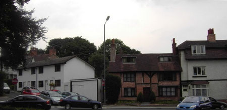
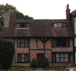
Take a look at the Old Smithy.
While no visible evidence survives of Maney Mill, the Old Smithy at Maney Corner, at the junction of Birmingham Road and Manor Hill is a cottage of medieval origin. The oldest part to the rear is
a rare local survival of a 14th-century cruck-framed cottage. At the front the house has additions and alterations of the 15th, 17th, 19th and early 20th centuries. This Grade II Listed building
was the house of the blacksmith whose forge was at the corner of Church Road and Maney Road.
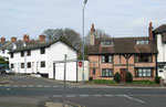
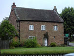
Take a look at the Old Stone House.
Also Grade II Listed is No.4 Maney Hill Road, which is known as a Vesey house. In the early 16th century Bishop Vesey built fifty-one such stone houses as a support to his relations and partly to
stimulate the local economy. This one is the largest of the five which survive.
On his visit to Sutton in 1538, John Leland wrote:
He [Bishop Vesey] buildyd dyvars praty howsys of stone in the forest, and plantyd his pore kynesmen in them, allotynge ground conveniently unto the howsys, for the whiche the
tenaunts bere the Kynge a mean rent.
Built of local red sandstone, this Vesey house has original oak beams and wall panelling, a spiral staircase, fireplace and floorboards. Formerly a farmhouse, it was later church property used as
the verger's residence and known as the Old Stone House. The house is now a domestic residence and in private hands.
For other Vesey houses see High Heath, Little Sutton, Reddicap and Walmley.
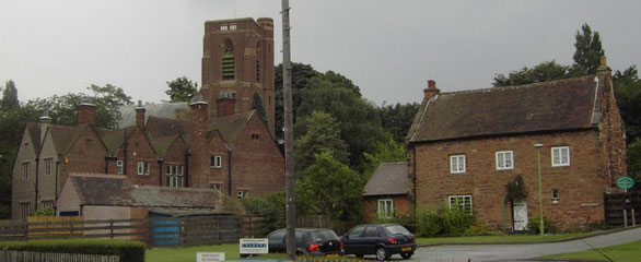
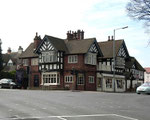
Take a look at St Peter's church.
In 1877 a simple corrugated iron building known as the Iron Church was built next to the Old Smithy. It had a small spired bell-turret to call worshippers from the hamlet of Maney who were now spared the up-hill walk to Sutton parish church.
As the urban build-up from Sutton town centre continued, it was decided to create a new parish out of that of Holy Trinity.
A new church was built in 1904 on Maney Hill Road by the well-known Birmingham architects, Cossins, Peacock & Bewlay. Dedicated to St Peter it was designed in perpendicular style with Arts & Craft details in brick and terracotta as befitted a thriving middle-class area. A tall square south-west porch and tower was built in 1935 conforming to the original plan.
Click to enlarge the images in the Maney Gallery.

William Dargue 06.04.2009
For 19th-century Ordnance Survey maps of Birmingham go to British History Online.
Map below reproduced from Andrew Rowbottom’s website of Old Ordnance Survey maps Popular Edition, Birmingham 1921. Click the map to link to that website.