Sutton/ Sutton Coldfield
formerly in warwickshire - one of the Domesday manors of Birmingham and ancient parish
B72 - Grid reference SP120960
Sutone: first record in the Domesday Book 1086, Sutton in Colefeld 1242
Sutton was a settlement founded by Anglians, probably in the 6th century, on the Birmingham sandstone ridge. The soil here is lighter and easier to farm than the heavy clay found to the west. John Leland in 1538 travelled
from Sharford [Salford] to Southeton 4. miles by sandy grownde, betar wooyd than fertile of whete. For the common corne there is some rye, barley, and ots. . . . The soyle is sandy and dry, and good for conyes [rabbits].
Sutton is first recorded in the Domesday Book in 1086. It is a name commonly found across the country and comes from the Old English suth tun meaning 'south farm'. It is not known where
it was south of - perhaps the ecclesiastical centre of Lichfield, maybe Tamworth which was later to be the capital of the Anglian kingdom of Mercia, or possibly it was named as being in the south
of the Chase.
The centre of the town lies in the river valley of Plantsbrook. The north of the town centre is built on higher ground on the Sutton plateau, which covers an area between Aldridge and Hamstead in
the west and Bassetts Pole to Tyburn in the east. The plateau is made up of sandstone and pebbly sandstone conglomerates underlying Sutton Chase. East of Sutton the land is mercia mudstone,
commonly known as red clay, and further to the east the wide floodplain of the River Tame. Various glacial deposits are found locally throughout the area.

By the Middle Ages Sutton was often referred to as Sutton-in-Colfield. John Leland writing c1538 called it the towne of Southeton apon Colefeeld stondinge in Colefeld hethe. Col may be 'charcoal'; certainly charcoal burning was an important occupation here, the first record of the town as Sutton in Colefeld occurring in 1269. The burners supplied fuel for iron smelting processes at least until the 16th century, by which time the supply of timber was almost exhausted.
However, the name possibly means 'cool, cold'. This could suggest an inhospitable or a barren place, but the adjective was also used to mean 'calm, tranquil'. A third explanation derives from the Celtic word colle meaning 'hazel', as found in the name of the River Cole. Hazels are certainly trees that thrive in stony soil and are still common in Sutton Park. However, Celtic survivals are very rare in our area, and its late record militates against this.
The final placename element feld means 'field'. However, unlike the modern concept of a field as an area of farmed land enclosed by a hedge or fence, the Anglo-Saxon word denoted 'open
country' as opposed to forest. See also The Coldfield.

The Domesday Book records that, in the time of Edward the Confessor, the manor of Sutton was held by the Anglo-Saxon Earl Edwin of Mercia, and in 1086 by King William himself. For tax purposes it was a manor worth four times the value of Birmingham with land for 22 ploughteams against Birmingham's possible six. However, in Sutton only eight ploughteams were at work after the Conquest.
With 10 acres, c4ha of meadow it had more than any other Birmingham manor. And only Yardley with 100+ hectares had a greater amount of woodland than Sutton. However, the taxable value of Yardley's woodland stood at 40 pence, while Sutton's, when exploited, was worth 30 shillings ie. 360 pence.
The manor remained in the hands of the Crown until Henry I exchanged it with Roger, Earl of Warwick for two Rutland manors c1135. Sutton then descended, with short exceptions, with the earldom of
Warwick until 1492 when it reverted to the Crown with whom it remained until Sutton became an incorporated borough in 1528.
Built by the Earls of Warwick, Sutton Manor House stood on Manor Hill and is documented as early as 1315. This may have been built as a hunting lodge for the earl and his guests. On the other
hand, the position of the manor house may suggest that this was the location of the first settlement of Sutton.
The Earls of Warwick were always absentee landlords and it is thought that the Mountfort family were in residence here from 1460 when Edmund Mountfort leased the manor and park. It may be this house which was described by John Leland in the 1530s as 'a praty hawle of timbar.'
That hall was later demolished and its timber frame was reconstructed at Bradgate House near Leicester, now in ruins. It is thought that Bishop Vesey had the stones removed for the construction
of Water Orton and Curdworth bridges over the River Tame. The latter has largely been rebuilt, but Water Orton's Vesey Bridge is still an important though narrow thoroughfare. Set into the side
of the bridge was a carved stone representation of the Archangel Gabriel from the manor house chapel. Believed to be part of an Annunciation scene, it was removed for safe keeping in 1926 and is
now inside Curdworth Church.
After 1540 a farm-house was built here by Bishop Vesey and occupied by one of his relations. The house passed through various owners but by 1762 was in a very poor state and occupied by a farm
labourer. By now the freehold was held by Sir Lister Holte of Aston Hall, after whose death in 1770 the manor-house, its mills and pools descended to Wriothesley Digby of Meriden. His grandson,
Lord Somerville owned the estate in 1860 and built a new house to replace the old farm. That house, known as The Manor in Manor Drive, still stands and is classified as a Grade II Listed
building.
Medieval Sutton under the Earls of Warwick was a thriving market town which held an annual fair. However, it began to decline after 1489 when it became a royal manor:
After that the erledom of Warwike was attayntyd and cam to the King's hand, the towne of Southton stondynge in a baren soyle fell dayly to decay, and the market was clene forsaken.
John Leland Itinerary in England and Wales in or about the Years 1535-1543

Tudor Sutton
Its restoration was due to a local boy made good, John Harman, Bishop Vesey of Exeter who was a close adviser of Henry VIII. On returning to Sutton for his mother's funeral in 1524 he found the town in decline, the market place deserted and the manor house demolished. Henry VIII agreed a charter of incorporation for Sutton in 1528, which replaced the lord of the manor by investing the government of the town in a newly-created corporation, the Warden and Society of the Royal Town of Sutton Coldfield. This was, in effect, a self-perpetuating oligarchy made up of prominent local inhabitants.
John Harman, alias Veysey, Bisshope of Excestar borne in this towne, much manetynge the decay of it got a new prevelege of Kynge Henry the 8. for restorynge the market there, and began to
repayre and build new howses ther, and furtharmore obtayned licence to deforest the chace there;
whereupon he buildyd dyvars praty howsys of stone in the forest, and plantyd his pore kynesmen in them, allotynge ground conveniently unto the howsys, for the whiche the tenaunts bere the Kynge a mean rent;
besydes this the place where the Erle of Warwiks old howse was, is now convertyd to the use of a fermars howse, and in it dwellythe one of the bisshop's kynesmen.
The byshope hathe also instituyd there a gramer-schole and endweyd it with lands.

Take a look at Bishop Vesey Grammar School, which was built in 1528 next to Holy Trinity Church. The building fell down c1700 and the school moved to its present site on the Lichfield Road in 1729. The old schoolhouse seems to have been demolished c1832 when the graveyard was extended and the school itself demolished sometime later. The central part of the present three-storey front block, has five bays with a parapet and is the original Georgian building but with 19th-century window alterations. The turretted stone hall to the right was built in 1887 and the whole enlarged many times during the 19th and 20th centuries.
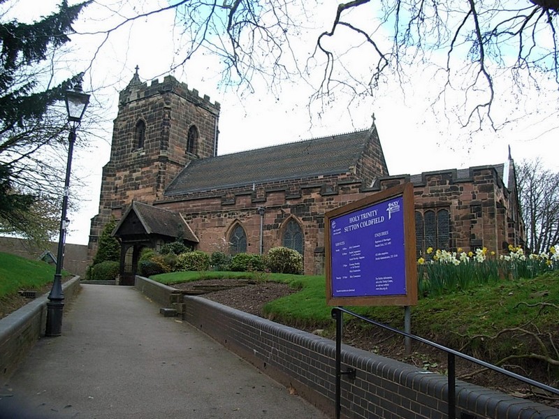
Bishop Vesey died in 1554 and his remains lie in a fine tomb in Holy Trinity Church.
Vesey was a very wealthy man. He retired as bishop with an annual pension of £500, a large sum in Tudor times - a labourer at this time would be very lucky to earn £20 a year). When in 1520 Vesey
had attended the Field of the Cloth of Gold summit between Henry VIII and Francois I of France, Vesey took with him 4 chaplains, 6 gentlemen, 23 Servants and 20 horses.
After 1527 he built Moor Hall and lived in style, employing more than 140 servants dressed in livery of scarlet caps and gowns. Here he died in 1554; he was buried in Holy Trinity Church where he lies beneath an impressive tomb.
The Warden and Society set up by Vesey administered Sutton for nearly 360 years until it became a borough with its own mayor in 1886, technically no longer a Royal Town. With the re-organisation
of local government in 1974 the City of Birmingham was combined with the Royal Borough of Sutton Coldfield to form Birmingham Metropolitan District Council, known as Birmingham City Council from
1986. Sutton's Tudor rose now forms part of the City's coat-of-arms.

The original location of Sutton Town was the High Street at the top of the hill near the church. This was little more than quite a compact village even by the time of the 1861 Census. Houses lower down the hill in Mill Street were occupied predominantly by labourers and their families, many from Ireland.
Of the 20 houses listed, nearly 50 of the residents were born in Ireland. Many are recorded as agricultural labourers, but they may have originally been drawn here to build the Sutton Branch Line from New Street which opened in 1862.
Sutton High Street has some 40 dwellings listed with the location described as ‘Town' (as opposed to country). The Tuns public house is here as are a number of shops, butchers' shops, a grocer's
and a bakery.
There were also small cottages here housing railway and agricultural workers, but there were also some substantial houses owned by landed proprietors and staffed with a number of servants.
In 1300 a royal grant was made giving Guy de Beauchamp, Earl of Warwick permission to hold a weekly market on Tuesdays, and an annual fair on the eve and feast of the Holy Trinity and for the
following two days. The market may not have been successful and the grant was made again in 1353 when a similar charter was given to Earl Thomas of Warwick with the addition of another fair on
the eve and feast of St Martin.

The building of Holy Trinity Church on Church Hill also dates from about this time; the first rector, Gregory Harold was appointed in 1305. The focus of the town then effectively spread northwards.
The church has been altered and extended a number of times since it was first built. However, early 13th-century plinths and buttresses in the lower part of the east wall of the chancel can still
be seen of the medieval building. Like many of Birmingham's ancient churches, the sturdy tower was built in the late 15th century. The north and south chapels, an extended nave, aisles and the
porch were added c1533 by Bishop Vesey.
During the 18th century the church was subjected to typical innovations of the time: galleries were built around the church, including family ones for the Ffolliotts of Four Oaks Hall and later
another for their successors, the Luttrells. In 1758 due to poor foundations much of the nave collapsed and in the rebuilding the opportunity was taken to make more radical 'classical' changes to
the church: box pews were constructed throughout, the pulpit was set up in the chancel, its tester supported on Corinthian columns with a reading desk in front.

The focus of the Church of England had moved away from the sacrament of communion to the preaching of the Word. This was a costly operation but was funded by the Warden and Society of Sutton by the sale of timber from Sutton Park. The old stone font was replaced with a white marble basin on a classic pedestal. In 1828 further galleries were built above the side chapels for the children from the newly-opened Town School. The children did not come into church through the main door but through doors specially made in the east wall whose outlines outside may still be seen.
In the third quarter of the 19th century fashions changed again and there were moves to restore the church to its original gothic style. All but one of the galleries were removed, the nave roof
was rebuilt to a steeper pitch, and the chancel was raised. Carved oak panelling was bought from Worcester Cathedral to make the choir stalls and screens. And the pulpit was moved back to its
traditional position at the side of the chancel arch. The marble basin of the 18th-century font was placed inside a stone one which had been donated by the church at Over Whitacre church. Dating
from the Norman period it is the oldest thing in the building. In 1914 C E Bateman painted the chancel ceiling and later the nave and Vesey Chapel ceiling.
There were certainly five bells in Bishop Vesey's time and probably before. A new ring was hung in 1784 replaced only ten years later by a six by Mears of London. Two additional bells by Taylor's
of Loughborough were hung in 1884. In 1965 the bells and the bell frame were in need of repair, but it was to be 1973 before the bells were rededicated.
Sutton Mill
There were a number of dammed fish ponds in the Park, but one pool in the town at the bottom of Mill Street was a mill pond. The dam served as a way into the town. Leland described 'a
strong waule of stone, and there is an arche in it thrwghe the whiche a coming out of the poole rennithe, and dryvethe a mill.'
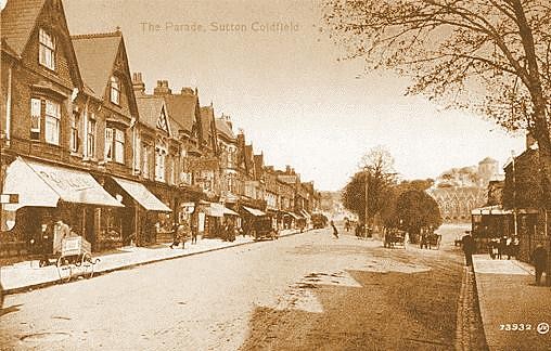
The brook was E(ast)brook, also known as Plantsbrook, which is now culverted under the Parade, that road being the course of the dam. The mill is believed to date from the time of the
Anglo-Saxon, King Athelstan r.925-940, and is documented in 1298. The dam was breached in 1668, the mill was damaged and there was serious flooding in the town. The ruined mill building was never
rebuilt and the pool was subsequently drained. When in 1826 the Lichfield turnpike road was constructed across the dam, the level of the dam across the valley was raised, and the roadway at the
top of Sutton Parade still suggests the raised dam.
Sutton was not noted for its agriculture although there is fertile country especially in the east of the manor. William Camden described the town in 1610 as lying 'in a foresty, unkind,
and barren soil'. Industry was developed in the late 17th and early 18th centuries when the streams in Sutton Park were dammed to form pools and mills were built on them. They were used
to manufacture a variety of products from buttons and blades to leather production and cotton weaving.
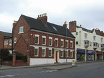
A substantial area around the High Street is designated Sutton Coldfield Conservation Area. Perhaps the oldest buildings here are on Coleshill Street near the parish church. A mid-18th-century
house is actually built around a medieval structure, another early 18th-century house has late 15th-century sandstone remaining in the side wall. Coleshill Street and the High Street represent
the best group in Birmingham of 18th-century buildings. Many are Grade II Listed. A number of houses in the High Street are of 17th-century origin though altered during the 19th century.
The buildings in the Gallery below are to be found along Coleshill Street behind Holy Trinity Church.
Click to enlarge.


On the Lichfield Road the Grade II Listed Moat House was built in 1679 by architect Sir William Wilson for his wife Jane Pudsey in Queen Anne style. This large extravagant five-bay house is built in brick with much stone dressing. The moat survived until 1860 before which time the front door was reached via a stone bridge.
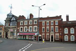
On the High Street the Royal Hotel was a large Georgian town house c1750 with a walled garden the walls of which survive. In the mid-19th century William Grundy, a tanner, lived
here, a pioneer of photography. By the end of the century the house was converted into the Swan Hotel, and c1910 it became the Royal Hotel.
Also on the High Street the Three Tuns public house, Grade II Listed, is a late-18th-century building which retains earlier foundations and cellars. Henry VII is said to have stayed here en route to victory at the Battle of Bosworth, Oliver Cromwell is reputed to have met his officers here after the Battle of Worcester, and Joseph Priestley certainly stayed here in 1791 after the burning of his house in the Birmingham Riots. The sculptor William Woodington was born here; he carved some of the bas-relief at the base of Nelson's Column in Trafalgar Square London. There are more than two dozen buildings along the High Street which are Grade II Listed making it well worth a visit.

The Lichfield Road
Sutton lay on an important national route, the Lichfield Road from Birmingham. From Roman times this road linked the south-west of England with the north-east. In 1807 a turnpike trust was set up from Birmingham along the Lichfield Road as far as Watford Gap where it joined the Lichfield Turnpike. Branching off it, the turnpike from Sutton Coldfield to Bassetts Pole linked to the Tamworth turnpike to the Watling Street.
A tollgate was set up at the junction of the Lichfield Road with the Tamworth Road; another at the junction of the Tamworth Road with Fox Hill Road Colletts Brook Farm was originally a tollhouse. Currently in a very dilapidated condition, this is a Grade II Listed building. Both routes were disturnpiked in 1872.
Sutton remained a small rural town until the 19th century. Eliezer Edwards writing in 1877 remembered his first visit about 1837: Sutton Coldfield was a far-off pleasant spot for pic-nics; but, to the bulk of Birmingham people, as much unknown as if it had been in the New Forest of Hampshire.
And in 1848 Samuel Lewis's Topographical Dictionary of England described Sutton as
pleasantly situated on a steep acclivity, on the road from Birmingham to Lichfield, [it] consists principally of one long street, the houses of which are mostly modern, well built, and of handsome appearance.
The inhabitants are amply supplied with water from springs; and the extensive park immediately adjoining, in which they have the right of pasture, with the privilege of sporting at all times, renders the town a desirable place of residence. The parish is . . . chiefly arable, with a due proportion of meadow, pasture, and woodland.
The surface is boldly undulated, the scenery finely varied, and enriched with stately trees; the soil is in general light and gravelly, and there are some extensive quarries of freestone.
The park was part of the ancient royal chase, and abounded with valuable timber: the numerous large oaks and other trees.

Birmingham to Sutton Branch Line
However, its popularity as a residential suburb increased dramatically with the opening of the Sutton Branch Line from New Street Station in 1862 and by the end of the century Sutton became a much sought-after district for the middle class and the wealthy.
It status was greatly increased by the developments on the Four Oaks Park estate where houses of great size and style were built from the 1890s.

The centre of Sutton Coldfield moved downhill from the High Street and Mill Street during the 20th century and has developed as a busy shopping centre, much of which was redeveloped in the later years of the 20th century. And the urbanisation of the rural parts of the old manor has continued fitfully until the present.
The east side of Sutton has now been designated as protected green belt land. Sutton now covers about a fifth of the City's ground area though with a much lower density of population.
For information on districts and locations in Sutton Coldfield see also Arden Hill, Beyond the Woods, Boldmere, Doe Bank, Eachelhurst,
Falcon Lodge, Four Oaks, Grove End, High Heath,
Hill, Langley, Ley Hill, Little Sutton,
Maney, Manor Hill, Mere Green, Moor Hall,
New Hall, Over Green, Peddimore, Penns,
Reddicap, Roughley, Streetly, Sutton Chase,
Sutton Park, Sutton Woods, Thornhill, Walmley,
Walmley Ash, Wiggins Hill, Wishaw and Withy
Hill.


William Dargue 07.03.09/ 03.05.09
For 19th-century Ordnance Survey maps of Birmingham go to British History Online.
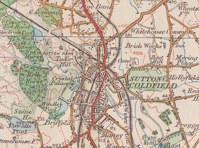
Map below reproduced from Andrew Rowbottom’s website of Old Ordnance Survey maps Popular Edition, Birmingham 1921. Click the map to link to that website.