Small Heath
B10 - Grid reference SP091862
Smallhethe: first record in 1461

Neither the forested lands on heavy clay of east Birmingham nor the light pebbly soils to the west were very conducive to early agricultural exploitation. And this remained true in the Roman period during the first four centuries of the Christian era.
However, sparse though the population may have been, there is evidence scattered across the Birmingham area that England was very much a part of an empire that stretched from the Atlantic to the Middle East. In every district in Birmingham Roman coins have been found, and Small Heath is no exception. Two Roman coins were unearthed in Oakley Road and a follis of Licinius (AD 308-324) discovered in Arthur Street. And there are surely many more Roman coins awaiting the keen-eyed gardener.
Before the end of the 19th century Small Heath was not an area of settlement and the name was applied only to a particular location, a narrow heath between Green Lane and the Coventry Road, a
site where the baths and library were to be built.
Poor agricultural land lying on glacial drift of sand and gravel, heathland provided adequate grazing for livestock. The modern district, which is situated around the Coventry Road between Small Heath Highway and Green Lane/ Yardley Green Road, remained largely agricultural until the last quarter of the 19th century.
The Coventry Road, around which the district was to develop, was first recorded in 1226 although it is certainly much older. Leading from the Digbeth crossing of the River Rea,
the road was a vital trade route from the medieval market town of Birmingham to Coventry, a major city of national importance. In 1745 the Coventry Turnpike was created with tollgates at Watery
Lane Middleway, Green Lane and at the River Cole. At Holder Road a milestone showed 105 miles to London.

The Warwick & Birmingham Canal, now the Grand Union Canal, which skirts the southern edge of Small Heath, opened in 1799 from Warwick Bar in Digbeth to Warwick. Although only 40 km in length and passing through more than forty locks, it nonetheless provided access to a route to London some 60 miles shorter than that of the Fazeley Canal via Coventry and Oxford. The line was later widened to its present broad-gauge of 14 feet and remained an important route until the Second World War.
The southern edge of Small Heath is also defined by the Birmingham & Oxford Railway which follows the line of the Warwick Canal. Designed by Isambard Kingdom Brunel to link up with the Oxford-Paddington line, it was laid in dual gauge, both broad (7 feet ¼ inches) and narrow (4 feet 8½ inches). In 1852 the journey from Snow Hill to Paddington took two hours forty-five minutes.

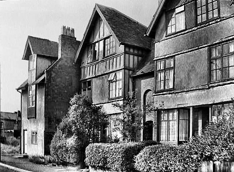
Small Heath was a scattered rural community with no village focus. By 1834 a small development of large houses had been laid out east of the Small Heath between Green Lane and Grange Road. These were the homes of the upper-middle class set in the countryside away from the booming industry of inner Birmingham.
However, during the next fifty years urban development reached eastwards as far as Charles Road with extensive estates laid out for the working class. Houses were built of brick from local clay pits and brickyards. Indeed building land was advertised with its assets of clay.
St Andrews Football Ground on Cattell Road was built on the site of a former claypit. Members of Holy Trinity Cricket Club, Bordesley first set up the club in 1875 as the Small
Heath Alliance Football Club as a way of maintaining their fitness during the winter months. When Birmingham received its city charter in 1889, the club was renamed Birmingham City Football Club.
See St Andrews.
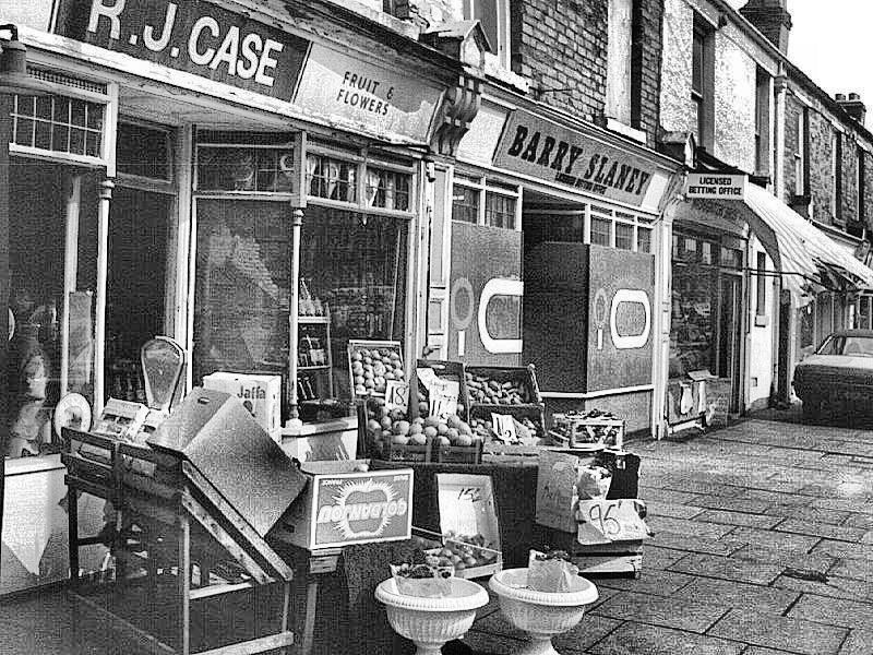
By 1906 the built-up area of Small Heath had reached Mansell Road/ Oldknow Road with urban Bordesley Green to the north and Sparkbrook to the south. Farmland remained to the east, although Hay Mills was coming closer. Gradually the entire length of the Coventry Road in Small Heath developed as a linear shopping centre.
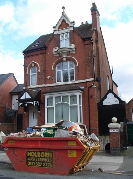
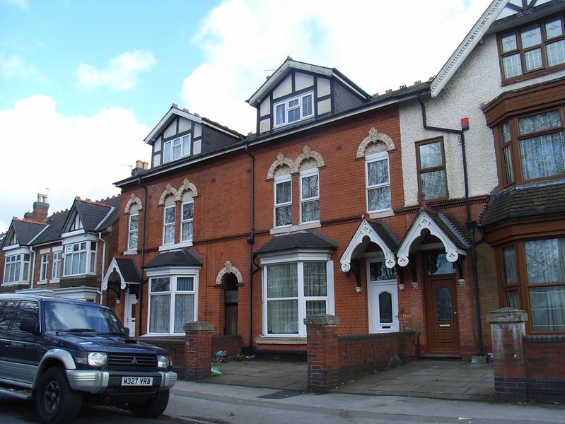
Parts of Small Heath have been rebuilt from the third quarter of the 20th century, but many good Victorian houses survive. The modern district lies around the Coventry Road between Small Heath Highway and Green Lane/ Yardley Green Road. Home to many Irish immigrants during the first half of the 20th century, many Asian families began to settle in the district especially from the 1960s.

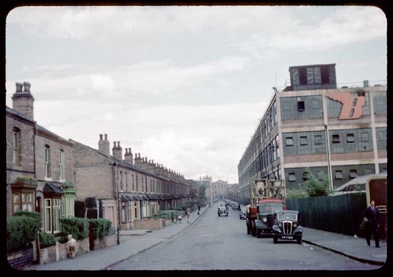
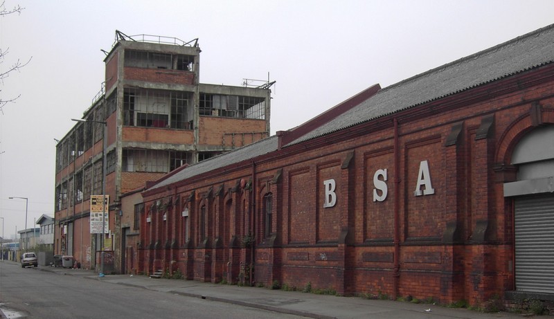
Small Heath & Sparkbrook Station was built on Golden Hillock Road in 1863 specifically to serve the new Birmingham Small Arms factory in Armoury Road. The BSA had been founded the previous year by a group of sixteen small firms of gunsmiths intent on mechanising manufacture in this labour-intensive industry.
The BSA
A large three-storey building in italianate style was built on a site covering three hectares. During the Boer War the BSA made two and half thousand rifles a week for the British army and in 1915 during the First World War the building was extended to increase production of Lee Enfield rifles to some ten thousand a week.
From 1880 bicycles were made here and by 1914 motorcycles and then cars were made. The BSA continued to be an important muntions manufacturer during the Second World War. The building was hit
twice by German bombs on 19 November 1941 and again two nights later. Fifty-three workers were killed. Not all their bodies were recovered and their remains were buried beneath the rebuilt
factory. Munitions production was transferred to other Birmingham sites and after the war Armoury Road gained a world-wide reputation for the manufacture of motorbikes. Unable to withstand
Japanese competition, the BSA closed c1980 and most of the buildings were demolished by 1983.
Opened in 1904 by the Lord Mayor of Birmingham, Sir Hallewell Rogers Small Heath Bridge, first known as New Bridge, crosses the Warwick & Birmingham Canal and the Birmingham & Oxford Railway with a span of two hundred metres to join Jenkins Street and Kendal Road. There has previously been no access from Small Heath to Sparkbrook between Sandy Lane (now Bordesley Middleway) and Golden Hillock Road.

Small Heath Park/ Victoria Park on the Coventry Road was a far-sighted venture securing a large green space on the edge of the burgeoning urban development. It was laid out in 1878 on the fields of Rylands Farm and given to the town council by Louisa Ann Ryland who also paid for most of its construction. Much of the work was carried out by gunsmiths from BSA during the munitions slump after the end of the Franco-Prussian War.
En route to open the Law Courts in town, Queen Victoria's train stopped at Small Heath Station where she was welcomed by fifty thousand schoolchildren. Queen Victoria asked that the park be named after herself, but by the 1930s the name had fallen out of use. The park's opening is commemorated in the Jubilee windows in the Great Hall of the Victoria Law Courts in Corporation Street.
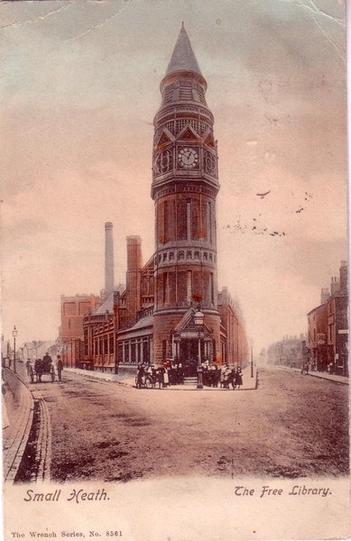
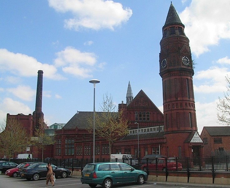
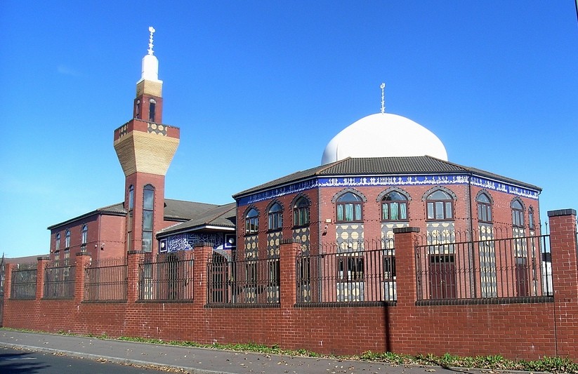
Another much-needed facility was Small Heath Library & Baths on the triangular corner site at the junction of Green Lane and Little Green Lane. This was the area where the original small heath had been.

With the library opening in 1893 this was a joint project by the council's free libraries committee and the baths committee. The rather austere building was designed by Martin & Chamberlain in red brick and terracotta with the library entrance at the foot of a round clock tower topped by a conical roof.
The baths opened 1897 with its entrance in Green Lane and had two swimming pools and washing baths. Water was supplied from a well on site nearly 200 metres deep. The baths and library closed
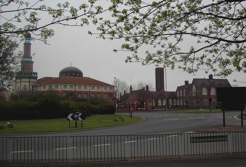
with the opening in 1977 of Small Heath Community School in Muntz Street with its integral library and swimming baths. The old building was been converted into a mosque and Muslim community
centre from 1980; it was refurbished in 2002 and has a prayer hall which will accommodate 2500 worshippers.
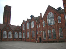
Small Heath Schools
After the passing of the 1870 Education Act, the Birmingham School Board opened its first Small Heath school in Jenkins Street in 1873. With a rapidly expanding population the board had
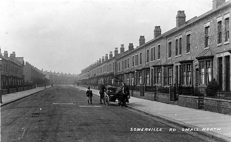
difficulty accommodating the increasing number of children. Schools were built in Dixon Road in 1879, Oakley Road 1889 and Somerville Road 1894. Provision for Roman Catholic families was made at
Holy Family School in 1904, and with provision being extended to a wider age range and the area still expanding Oldknow Road Council School was opened in 1905 and St Benedicts Road in 1913.
Waverley Road Higher Grade Board School was opened by the Birmingham School Board in 1892 with accommodation for over five hundred pupils. The towered building by Martin & Chamberlain is in
brick with terracotta dressings. It specialised in industrial and commercial courses. Renamed Waverley Council Secondary School in 1933, it subsequently became Waverley County Grammar School
after the passing of the 1944 Education Act. The school moved into new premises in Hob Moor Road but the original buildings continue in use as part of the Small Heath Community School in Muntz
Street. The buildings are Grade II* Listed.
Oldknow Road Council School opened in 1905 to accommodate 1070 children; it was reorganised in 1928 for senior boys, senior girls and infants, the infant department closing in 1937. The school was hit by a German bomb in 1940. Part of the building was used by Holy Family Roman Catholic School for six years after 1944 German bombs having badly damaged their own building. The school was renamed Oldknow County Modern School 1954. The school, No.78, the railings and gate piers are Grade II Listed. It is now a primary school.
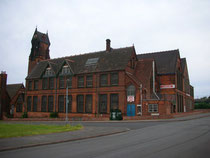
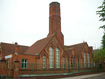
Click to enlarge the images of Small Heath schools below.


Small Heath Churches
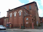
Catering for the religious needs of this rapidly developing area, a host of churches, chapels and mission rooms were built during the last quarter of the 19th century in a variety of architectural and religious styles. Notable amongst those surviving is St Oswald of Worcester, an early design of W H Bidlake in early English gothic style on St Oswalds Road.
This Grade II* Listed building consecrated in 1893 has wooden ceilings throughout and carving in the chancel; the statue of St Oswald was carved in 1921 by George Latham, a nineteen-year-old parishioner. The Grade II Listed vicarage in Dora Road is also by Bidlake but in Arts & Crafts style.

This image of St Oswald's is from the American Architect and Building News 1891 reproduced here with permission from the St Croix Architecture Prints website.
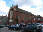
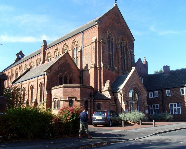
Also Listed Grade II* is St Aidan's Church which opened in Herbert Road in 1894. It is designed in perpendicular style and built in Birmingham red-brick and terracotta. Intended from its conception to be a high church, its first priest Rev James Agar-Ellis was a follower of the Oxford Movement.
The nave is large and lofty, and the chancel is wide with a rood and screen by F Bligh Bond which was installed in 1912. In the baptistery stands a 15th-century font brought from St Stephen's Church, Bristol. Stained glass in the west window is by the noted Birmingham glassmaker, John Hardman whose work is to be found in a number of local churches.

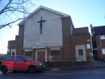
All Saints Church on Cooksey Road was designed by A E Dempster. Built in brick in early English gothic style it opened in 1875. The church was destroyed by German bombs during World War 2; All Saints Shard End was considered a replacement for this church.
From the 1970s the area saw an influx of immigrants especially from the Indian sub-continent. Added to the general decline in numbers attending church, congregations fell below practicable levels and it was decided to close St Gregory's and St Oswald's, the former being sold in 1996 to the Bethel United Church, the latter in 1998 sold for community use. The rood of St Oswald's given in 1920 as a war memorial now hangs in St Michael's Church, Great Torrington in Devon.
It was decided to concentrate the efforts of the combined parishes on the St Aidan's church building. Renamed as All Saints' Church, extensive alterations have been carried out. The former vicarage was converted for use as a community facility and a new clergy house was built in 1999. Work on the church was completed by 2001. The church maintains a High Anglican tradition.
Click to enlarge the church photographs below.


Public transport
The first horse-drawn tram line in the Midlands was laid to West Bromwich in 1872.
However, it was to be another thirteen years before a tram route from town reached Small Heath Park. This remained the limit for nearly twenty years when the old turnpike bridge across the River Cole was replaced, the line reaching The Swan Yardley by 1907.
After fifty years service the Coventry Road tramway was in poor repair, the trams were old and the route no longer profitable. The decision was made to convert the route into a trolleybus line.
Because of the smoother quieter ride, previous conversions had proved very popular, resulting in a 50% increase in passengers.

Birmingham Transport Committee ordered fifty GEC trolleybuses, the bodies of which were to be manufactured by Metropolitan-Cammell in Washwood Heath which operated from the Coventry Road depot in Bordesley from 1934.
Subsequent to the amalgamation of Sheldon with Birmingham the Coventry Road line was extended to the new city boundary in 1936. Until the Second World War the city had been able to take advantage
of its own cheap home-produced electricity. However, with the advent of electricity nationalisation and the fact that three quarters of the Coventry Road fleet needed to be replaced, the
Transport Committee decided to abandon trolleybuses for motorbuses.
On Saturday 30 June 1951 the last trolleybus left the depot carrying an official party for the last journey into the city to return at midnight.
During the second half of the century private and commercial motor traffic increased beyond any predictable forecasts and the dual use of the Coventry Road as a local and regional route became untenable. Small Heath had developed into a busy linear shopping centre from the original heath at Green Lane all the way to Small Heath Park. To bypass the local congestion, during the 1990s the Small Heath Highway was built alongside the Birmingham & Oxford Railway line from the Middle Ring Road at Bordesley to rejoin the Coventry Road at Hay Mills.


William Dargue 08.03.2009/ 19.08.2012
For 19th-century Ordnance Survey maps of Birmingham go to British History Online.
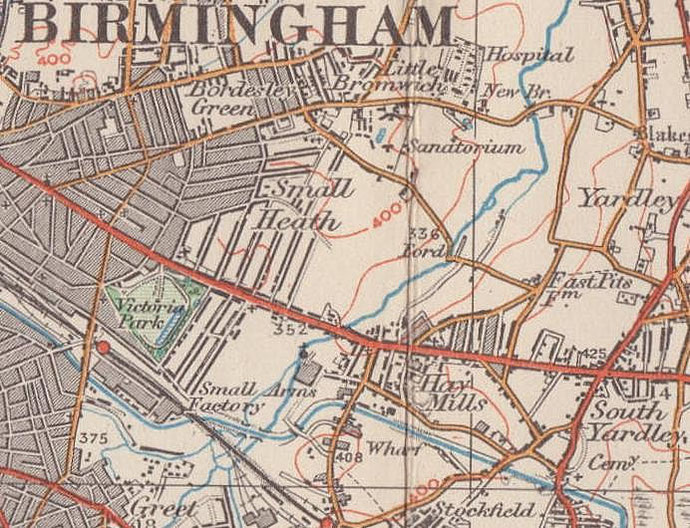
Map below reproduced from Andrew Rowbottom’s website of Old Ordnance Survey maps Popular Edition, Birmingham 1921. Click the map to link to that website.