William Dargue A History of BIRMINGHAM Places & Placenames from A to Y
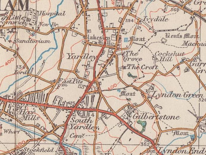
Blakesley
B25 - Grid reference SP130861
Blakleistoles: first record 1316

The name Blakleistoles, blac leah stoles, is of Anglo-Saxon origin and appears to mean 'a bleak clearing of (withy) stools'. These were willow trees which were cut, coppiced, every few years to just above ground level in order to provide long slender branches for fencing or for basket-making.
Willows are water-loving trees and prolific in the boggy valleys of Birmingham's rivers and streams, so the clearing could have been at the west end of Blakesley Lane nearer the River Cole.
There is a problem, however, in interpreting the first element of this placename. Three similar words in Old English lead to later confusion: one meant 'black', another derived from the word 'to
shine' and could mean 'shining, pale, or bleak', while a third variation had the same root as the verb 'to bleach'.
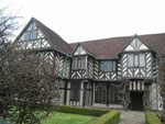
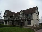
Well worth a visit - Blakesley Hall
In Blakesley Road, Yardley this Grade II* Listed building is the substantial farmhouse of the late 16th century and was built for Mr Richard Smalbroke gent, as he signed himself from the 1580s, the brother of Thomas Smalbroke, mercer of Birmingham. The Smalbrokes were related to such influential local families as the Devereux, the Estes and the Greswoldes.
Dendrochronologically dated in 1990 to a year exactly 400 years earlier, the house is timber-framed and jettied in a style typical of this part of rural Warwickshire and Worcestershire with the main timber-framed block infilled with lath and plaster. It has ideas above its station: there is a long gallery upstairs more typical of grander country houses and wall paintings in the first-floor bedrooms. On the ground floor are great and little parlours separated from the main open hall. This is a fine half-timbered building, but erected at the end of an era: the up-and-coming style was for houses to be built in a neo-classical style in brick. After the death in 1613 of Richard Smalbroke, his children predeceased, the hall passed to his niece and through her down through the Folliot family until 1685.
The hall was then bought by Henry Greswolde, the Rector of Solihull and let to various tenants as a farm. A brick kitchen was added on to the north side at this time with servants' quarters
above. In the 18th-century a range of timber-framed barns were built to the east of the house. During the 19th century the house was let as a country residence for members of Birmingham's upper
class. Larger windows replaced the small Tudor ones and the staircase was panelled with wood taken from the demolition of Christ Church in New Street in 1899 when the almost derelict hall was
restored.
In 1932 Blakesley Hall was bought by the City as a museum and furnished in Tudor style. During the Second War War German bombs destroyed the dairy and caused other serious structural damage and
the hall was closed for over ten years for repairs until 1957. In 2000 Blakesley Hall was extensively restored and a new visitor centre built to the rear.
However, the present building was not the first on the site. Excavations here have found evidence of a medieval building which stood east of the present hall. This would have been the home of
Richard Smalbroke's father, Richard Senior who died in 1575. He derived his wealth, not through farming, but through business dealings in Birmingham. One of the town's ruling class, he owned a
shop on the High Street and traded in iron products, textiles and spices. On his death his wealth and the Blakesley property went to his eldest son, Richard, builder of the present hall.
See also Camp Hill - Stratford House.

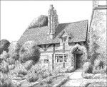
Blakesley Road, Vintage Cottage dating from the 16th century. It was demolished in the 1960s - drawn in 1948.
Thanks and acknowledgements for the use of this image to E W Green, Historic Buildings in Pen & Ink - The Work of William Albert Green.
Click to enlarge the images below.


William Dargue 13.09.2008/ 30.07.2010
For 19th-century Ordnance Survey maps of Birmingham go to British History Online.
Map below reproduced from Andrew Rowbottom’s website of Old Ordnance Survey maps Popular Edition, Birmingham 1921. Click the map to link to that website.