

William Dargue A History of BIRMINGHAM Places & Placenames from A to Y
Berwood, Berwood Common
B35 - Grid reference SP144912
The manor house of Berwood, a sub-manor of Erdington, dated from at least the 12th century and stood off Farnborough Road north of the roundabout on Trident Boulevard. The name Berwood is no
longer in use, but was still recorded on the Ordnance Survey map of 1889. It is Old English in origin. Bearu might be translated as a 'grove', but the implication is that this was open
woodland used as pig-pasture; wudu simply means a 'wood'. (See also Bearwood.)
Berwood Hall is first found documented in 1160 when Sir Hugh de Arden gave to the Abbey of St Mary at Leicester his manor of Berwood as a monastic grange. This would have been a farm run by lay brothers for the benefit of the monastery. Granges were usually within a day's walk of the mother monastery, so that the brothers could attend services on Sundays and holy days - in this case Leicester is about 40 miles distant.
The land here by the River Tame was fertile alluvial soil, but must have been always in danger of winter flooding. Maps into the 20th century still showed 'Liable to Floods' along
the Tame here. There was a watermill associated with the manor, probably situated on Plantsbrook near its confluence with the River Tame. Two priests were mentioned in 1224 as serving in the
chapel of the Blessed Virgin Mary at Berwood Hall, but the chapel had gone by the time of Henry VI d.1471. Following the fashion of the time, the hall was surrounded by a moat sometime in
the 13th century. Rather than serving a defensive purpose a moat was a medieval status symbol. With the dissolution of the monasteries under Henry VIII the manor reverted to the Crown
and was later sold to Thomas Arden of Park Hall, Castle Bromwich for £272.10 shillings.
Although not within the manor of Sutton Coldfield, Berwood was held to be part of Sutton Chase and continued to be administered as part of the lordship of Sutton until at least 1529. There was a hunting lodge here used as a residence by the keeper of that part of the chase. Royal or noble guests of the Earl of Warwick, whose hunting ground this was, would have stayed here when on hunting expeditions.
William Hutton visited the site c1780:
Berwood-hall, where the forsaken moat, at this day, guards--nothing. This, with the manor to which it belongs, was also the property of the Ardens; one of which in the reign of Henry the Second, granted it to the canons of Leicester; who added a chapel, which went to decay four hundred years ago. After the grant, the Ardens seem to have become tenants to the canons for the land, once their own: we frequently observe a man pay rent for what he sells, but seldom for what he gives.
At the dissolution of abbies, in 1537, Thomas Arden, the head of the family, purchased it of Henry the Eighth, for 272l. 10s. uniting it again to his estate, after a separation of three hundred and fifty years, in whose posterity it continued till their fall. Thus, the father first purchased what the son gave away, and his offspring re-purchased again. The father lays a tax on his successor; or, climbs to heaven at the expence of the son. In one age it is meritorious to give to the church, in another, to take from her.

In common with many moated halls, Berwood Hall had fallen into decay by the late 17th century, when the manor house was replaced south of the old moat by a farmhouse. During the First World War this building was used as the officers' mess of Castle Bromwich Airfield.
The farmhouse survived until the Second World War when aerodrome was greatly expanded for the war effort. During the 1960s the airfield was developed as a large municipal housing estate, Castle Vale.
The 1889 Ordnance Survey map shows the settlement of Berwood as located on the Chester Road east of Birmingham Road and Sutton Road. Houses were being built at that time as a result of the opening of Chester Road Station in 1862. See Chester Road.
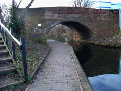
The name of Berwood Common is recorded in 1805 and is still marked by the name of Berwood Common Bridge. The bridge carries Berwood Lane/ Egerton Road across the Birmingham & Fazeley Canal which was built c1789. It is a typical canal bridge built in red brick with high parapets and a semi-circular arch and is Grade II Listed. The common was on the north side of the canal and lay between the Chester Road, Kingsbury Road, Holly Lane and Grange Road, the area now known as Pype Hayes.
Berwood Meadow and Berwood Moor are recorded as field names in a lease of 1773.
See Castle Vale.
William Dargue 26.01.2009/ 30.07.2010