William Dargue A History of BIRMINGHAM Places & Placenames from A to Y
Hall Green
B28 - Grid reference SP110817
Hawe Green: first record 1562
The centre of Hall Green now stretches along the Stratford Road, but the original green was neither here nor called 'Hall'. Hawe Green took its name from the medieval family whose moated hall stood at the junction of School Road and Fox Hollies Road near the green or common pasture.
The word 'haw' probably derives from the medieval word haga meaning 'hedge, enclosure, or enclosed land'. The family had taken their surname from this common placename, but whether that was here or elsewhere is not known.
Their home, Hawe Hall was later known as Hall Green Hall and was a timber-framed house which was extended in Tudor times and again in the 18th century.

Last occupied in 1935, the hall was sold and demolished for the construction of the Charles Lane Almshouses. School Lane from Fox Hollies Road to Studland Road follows the route of the drive to the hall.
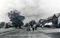
The modern centre of Hall Green has spread along the Stratford Road. This route is of great antiquity and was mentioned in the Yardley Charter of 972 AD as Leommannincg Weg,
'Leommann's Folk's Way'.
Being on firmer ground and with fewer difficult river crossings than the Warwick Road, it was for hundreds of years the preferred route to the county town of Warwick.
In 1726 the road was turnpiked and travellers paid their tolls locally at the Colebank Gate at the junction of Cole Bank Road and School Road. The Stratford Road was known as the London Road until Telford's improved Coventry Turnpike became a better route to the capital after 1801.

Of medieval origin, the Bulls Head at the Four Ways junction with Fox Hollies Road was rebuilt as a coaching inn in the mid-18th century. This was not a stage where horses were changed, but a request stop only. Writing in 1781 William Hutton said of the turnpike,
'To Stratford and Warwick, about twenty miles each, much used and much neglected.'
The road was disturnpiked in 1872.
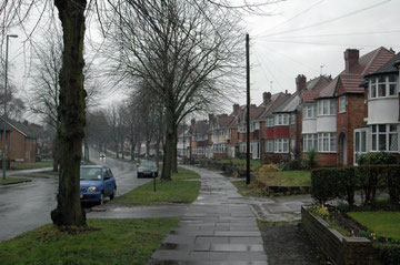
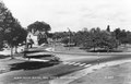
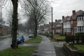
Although Hall Green as a residential district is a mid-20th-century suburban development, some traces of its past remain.
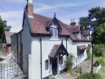
On Green Road the Chalet and its timber-framed barn were probably built during the Stuart period. The original timber-framed cottage stands at right-angles to the road and has an 18th-century brick extension built across the front; the rear was then encased in brick in the early 19th century.
About 1880 the house was again extended when a rear wing was added with gothic bargeboards, pinnacles, porch and stained glass. It is from this time that this Grade II Listed building was so-named.

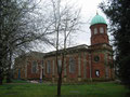
Take a look at Hall Green Church, a Grade II* Listed building which dates from 1703. Built as a chapel-of-ease of St Edburgha's, Yardley, it was financed by a bequest of Job Marston of Hall Green Hall which stood diagonally opposite. Sir William Wilson designed the church in Queen Anne style to be built in brick with stone dressings. This tended to be an urban style and, as few of Birmingham's 18th-century town churches survive, it remains one of the few neo-classical church buildings in the city.
The chancel and transepts added in the 1860s are unusual in that the extensions were in accordance with the original style, although by this time the Gothic Revival was under way. The church was given its own parish out of Yardley parish in 1908. Originally dedicated to the Holy Trinity but known also as the Job Marston Chapel, the church was renamed as the Church of the Ascension in 1954. The streets around the church form the Hall Green Conservation Area.

Hall Green School
The school too has a long history. In 1721 the master of a new school, the Hall Green Free School was left 20 shillings a year by Joseph Fox. The school had been set up by the Yardley Trust in
1710. Known by 1819 as the Hall Green Yardley Charity School, it took forty children free who were chosen by the trustees. In addition the master could also accept four paying boarders, which
must have helped to supplement his salary. A playground and a nearby garden were rented for the school, which was held in a plain Georgian building next to the present site of the Horse Shoes
public house at the junction of the Stratford Road and School Road. In 1881 the average attendance was twenty-six pupils.
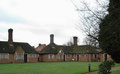
When the school closed in 1898, the children were transferred to Hall Green Board School. Another school, Hall Green National School was also in existence by 1833 with thirty girls being taught in a rented building with a single schoolroom. It transferred in 1890 to the Yardley School Board as Hall Green Temporary Board School and closed in 1893 when the new Hall Green Board School was built.
Take a look. The red-brick and terracotta school building of Hall Green opened with a teacher's house and accommodation for 240 girls and infants. Enlarged by 1930 and reorganised for juniors and
infants, it still serves the district as its primary school.

Hall Green is served by the Great Western's North Warwickshire Line to Stratford which in 1907 was the last suburban line built in Birmingham. Although the name Hall Green was being used to describe a location by 1562, it was only with the opening of Hall Green station in 1907 and the enparishment of the Church of the Ascension the following year that led to its use for the surrounding area.
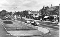
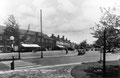
The district was urbanised between the world wars when large numbers of private houses were built, as well as large municipal estates at Fox Hollies, Gospel Farm and Bushmore Farm. The centre of Hall Green is now a long stretch of the Stratford Road either side of the station.
Hall Green Stadium opened for greyhound racing in 1927, one of Britain's first. The following year motorcycle speedway racing started on a circuit inside the dog track. However,
it was unpopular with local people who petitioned against the speedway and racing finally finished at the beginning of the Second World War. A football pitch was later laid out in the centre of
the track. In the late 20th century the facilities have been expanded with restaurants, bars, a snooker hall and hotel. The stadium closed in 2017 and housing was built on the site the
following year.
Click on the images in the Hall Green Gallery below to enlarge them.


William Dargue 15.03.2009/ 23.11.2020
For 19th-century Ordnance Survey maps of Birmingham go to British History Online.
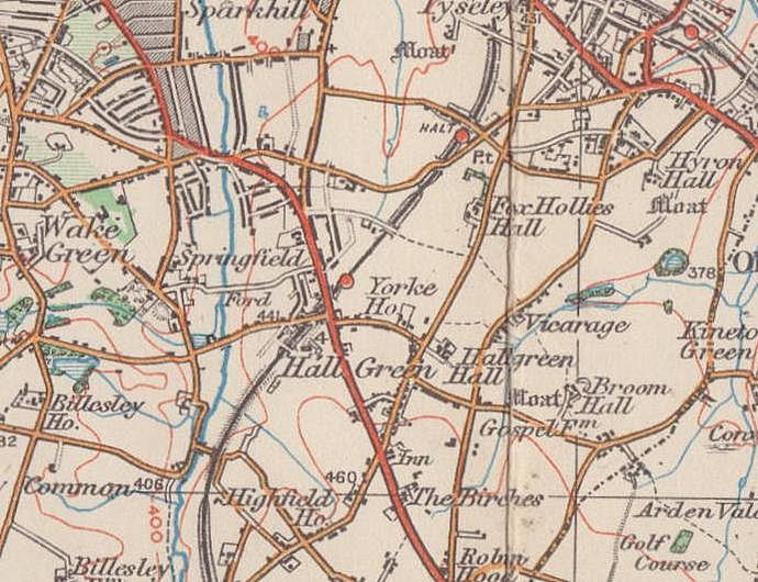
Map below reproduced from Andrew Rowbottom’s website of Old Ordnance Survey maps Popular Edition, Birmingham 1921. Click the map to link to that website.