

William Dargue A History of BIRMINGHAM Places & Placenames from A to Y
Nineveh
B21 - Grid reference SP047890
First record late 18th century
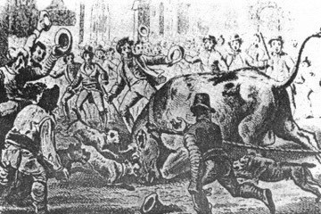
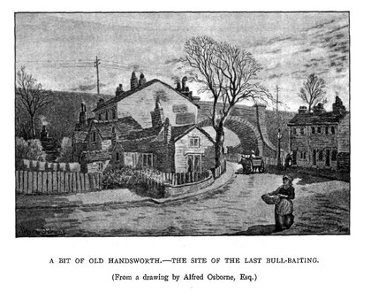
Nineveh was a rural hamlet on Birmingham Heath close to the Handsworth boundary . The last recorded instance of bull baiting, banned in England from 1773, is known to have taken place in 1838 at Nineveh. This was then a remote place. Showell's Dictionary of Birmingham 1888 held that,
Prior to 1756 the country on the Handsworth side of Birmingham was little better than barren heath, the home of conies [rabbits] and a few beggarly squatters, until Mr. Edward Ruston leased from the Lord of the Manor the whole of the piece of common that lay between Nineveh and Hockley on the left of the West Bromwich Road. He deepened the channel of Hockley brook, and built a small mill by its side, which being purchased from him in 1764 by Matthew Boulton formed the site of the once world-renowned Soho Works.
Robert Dent writing in 1880 in Old & New Birmingham spoke of ‘a scattered population . . .drawn into the neighbourhood of Soho and Hockley through the enterprise of Boulton and Watt.' Developed from after 1764, over a thousand people were eventually employed at the Soho Works in Factory Road.
J M Brindley described the rural neighbourhood in the 1830s when All Saints' Church was built:
When the church was erected, the suburb of Nineveh was far in the country, the nearest cluster of dwellings of any importance was at Hockley, in the neighbourhood of the Old Cemetery [Key Hill]. Farmhouses and cottages were scattered at intervals in the fields and lanes which surrounded the church on all sides. Looking from the Old Cemetery the church was the one prominent feature in the landscape, its dwarf spires rising above the surrounding trees.
From Key Hill a rural lane led up to it, lined with hedgerows, amid which twined the honeysuckle and the wild rose. Cornfields and hayfields were on either side the road. A lane to the left led through the meadows to Birmingham Heath. There was another way to the church from the bottom of Warstone Lane, over stiles by pathways through the fields, where murmuring brooklets crept along, where cowslips grew, and 'ladysmocks all silvery white' might be gathered for the trouble of stooping.
J M Brindley 1880 Church Work in Birmingham
The Birmingham Street Commissioners' Map of 1810 shows a scattering of cottages around the junction of Park Road and Bacchus Road known as Nineveh. The name is now recalled only in Nineveh Road which runs westwards from that junction. A large house, also called Nineveh stood where the park in Bacchus Road is now. It is probably the house mentioned in Showell's Dictionary of Birmingham in 1888: 'The first oven grate used in this district was introduced in a house at "the City of Nineveh" about the year 1818, and created quite a sensation.'
An Old Testament name
Why the hamlet was so-named is unknown, but it clearly has a Biblical origin. The city of Nineveh was the capital of the ancient Assyrian Empire, across the River Tigris from the modern city of Mosul in Iraq. It features in a number of books of the Old Testament. In the Book of Jonah c750 BC, the prophet was sent by God to call the wicked citizens of Nineveh to repent of their sins or the city would be destroyed. From the king down the citizens fasted and wore sackcloth and ashes and God spared the city. In the New Testament Jesus used the example of the people of Nineveh as a sign of repentance.
However, a hundred years after Jonah the Old Testament prophets Nahum and Zephaniah again denounced the city and foretold its destruction; Proud Nineveh for them is a symbol of earthly pride. The Assyrian empire was subsequently attacked by the Medes and the Babylonians and Nineveh fell in 612 BC. Its people were massacred or sold into slavery and the city was razed to the ground so effectively that its location was lost from memory until the mid-19th century when it was rediscovered by archaeologists.
Nineveh is a transferred placename, being the name of another place elsewhere and given to this location for reasons not now known. It is a name found across the country and tends to be used of farms or individual houses. Here it is no longer in for this location, other than as a streetname, and the district is now considered to be part of Handsworth, although historically the Handsworth boundary lay north of the area.
Whether the hamlet of Nineveh on Birmingham Heath was named after proud Nineveh or repentant Nineveh will never be known. It is probably the latter and is the type of Old Testament name given by members of the growing non-conformist movement in the second half of the 18th century.
There were certainly Methodists in the area at the beginning of the 19th century. Wesleyans from West Bromwich undertook missionary work among the workforce at Matthew Boulton's Soho works from about 1820. As a result of their success Benson Road Nineveh Chapel was built. It stood immediately west of Benson School. Opened in 1822 in a purpose-built brick building faced with stucco, there was accommodation for over 200 worshippers. The chapel was enlarged twice in the following years. By the outbreak of the Second World War membership had slumped and the chapel closed in 1958.
All Saints' Church was built east of Nineveh, but as the population grew and housing was increasingly built in the area from the mid-19th century, the church set up a large number of chapels and mission rooms around the district, including the Nineveh schoolroom which stood opposite Benson School.
When the parish was set up, it was very extensive covering as it did a large area a large part of the unpopulated Birmingham Heath. However, as the population grew after 1850, the church built a large number of subsidiary missions in the parish: St Simon's Mission in Heaton Street, St. Saviour's Mission in Icknield Street; Winson Street Mission, Park Road Mission, later consecrated as St Chrysostom's Church, St Michael's Mission in Camden Street, Heath Street Mission later consecrated as St Cuthbert's Church and St John's Mission in Crabtree Road to name but some.

Nineveh Infants' School or Gibb Heath Charity School opened in 1830 with accommodation for about 60 children under a single teacher in a single room. Children generally spent about a year here.
By 1841 it was known as All Saints' Nineveh Infants' Church School and in 1846 was in union with the National Society. (The National Society for Promoting Religious Education is a Church of England society set up to promote the National Religion as the foundation of national education. Their mission was to found a Church school in every parish in England and Wales by providing finance, support and teachers.)
The school closed in 1886 and children presumably transferred to Soho Road Board School opened two years later by the Birmingham School Board. Accommodating almost 1000 children, infants and juniors, the school changed its named to Benson Road Board School when the street name was changed. For some years before World War 1 additional accommodation was taken in Nineveh Wesleyan Chapel next door. The school is still in existence.
See also The Flat, Hockley.
William Dargue 07.04.2009/ 07.09.2012