William Dargue A History of BIRMINGHAM Places & Placenames from A to Y
Kingshurst/ Kings Hurst
B37 - Grid reference SP170884
Kyngeshurste: first record 1368
The name Kinghurst is medieval and means 'the king's wooded hill', though to which king this refers is not clear. The history of Kingshurst and the neighbouring manor of Coleshill are intertwined. It may be that Kingshurst was not always a separate manor and was once part of Coleshill.
Kingshurst is not mentioned in the Domesday Book in 1086 where Coleshill is listed as a royal manor. Coleshill remained the property of the Crown probably until the time of Henry I r.1100-1135 when Osbert de Clinton was granted the manor by the Crown. The Clintons remained lords until Joan de Clinton inherited in 1353. She married Sir John de Montfort and after their deaths the manor passed to their son, Baldwin de Montfort.
The manor of Kingshurst belonged to the Montforts, though from when is not known. It is known that Richard, son of Peter de Montfort was the lord of the manor c1368.
In about 1390 Sir William Montfort, son of Sir Baldwin Montfort was living here. He added much of his demesne land of Coleshill, of which he was also lord of the manor, to the manor of Kingshurst to bequeath to his son, Sir Edmund de Montfort. The latter was also a resident lord and it was he who created the deer park in 1447.
Simon Montfort entered into possession of Coleshill before 1461. He supported Perkin Warbeck's unsuccessful rebellion against King Henry VII and was tried for treason at the Guildhall in London in 1495, judged guilty and hanged, drawn and quartered. On Simon de Montfort 's attainder in 1495 the manor of Coleshill was given by the king to Simon Digby, the deputy Constable of the Tower of London, who had been responsible for bringing Simon de Montfort to trial.
It was argued by the Montforts, however, that Kingshurst had been a separate manor from time out of mind (ie. before the Conquest) and never had been part of Coleshill. It thus should not pass to the Digbys with Coleshill. Their assertion was that Kingshurst was conveyed to Sir Simon Montfort's grandson, also called Simon, in 1529. However which way, in 1534 the attainder against Sir Simon Montfort was reversed, and the grandson, Simon, was granted the manor.
The succession to the manor was contested again in the following century by the Digby family of Coleshill. Nonetheless, in 1578 George Digby conveyed it to William Mountfort who was still holding the manor (and park) of the king, by fealty and the rent of a red rose, at his death in 1610. However, in the early 17th century Sir Edward Mountfort passed away all his manorial rights to Sir Robert Digby, lord of Coleshill, and both manors are still in the hands of that same family.
Kingshurst lay in Warwickshire until local government reorganisation in 1974 when it became part of Solihull Metropolitan District Borough.
Kingshurst Norman castle
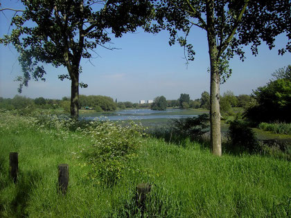
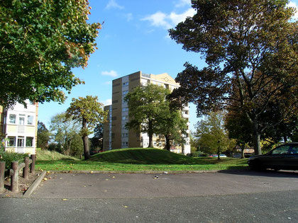
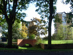
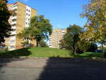
Kingshurst stands on a low hill above the floodplain of the River Cole and it was here shortly after the Norman Conquest of 1066 that a member (possibly) of the de Montfort family built a motte and bailey castle. A large mound still remains now encircled by the five blocks of flats on Stonebridge Crescent and Kingshurst Way. The motte now measures 4m in height with diameter of 10m across the summit and 25m across its base. The surrounding moat, now dry, measures some 15m wide and up to 1.5m deep.
In 1961, in advance of housing development, archaeologist F C Johnson cut a section through the mound and across its moat and discovered the motte to be of two periods. The first motte was a low
mound with a shallow revetted ditch. There was evidence of a sand floor here but no signs of any structure had survived. This motte probably dates from shortly after 1066 and was presumably
topped by a wooden castle or look-out tower, perhaps similar to that at Castle Bromwich at this same period.
Pottery finds date the second period of development to the second half of the 13th century. At that time the mound was significantly heightened, the ditch widened and deepened and an inner palisade constructed.
The first records relating to the de Montforts date from this time. Evidence of large post-holes in the interior clearly suggest the existence of a tower. North-east of the motte the bailey was much modified. It was here that a timber-framed house was built surrounded by a new moat which intersected the moat of the castle. The interior revetted stone wall of the bailey was dated as being of the 14th century.
During the reigns of William & Mary (r.1689-1702/ 1694) a new Kingshurst Hall was built presumably by the Digbys, to replace its medieval predecessor, which may have fallen
into decay. The new house was a large red-brick building of two storeys and had a steeply pitched tiled roof with dormer windows. Access across the medieval moat was via a brick bridge which
still exists. The hall almost filled the space within the moat whose inner revetting wall is of bricks probably of the same date as the hall, but resting on stone foundations. At the west corner
outside the moated enclosure is an earlier timber-framed stable.
Kingshurst Hall, park and farmlands were always let out by the Digby family, who were absentee lords of the manor. By the 18th century the tenancy was held by the York family who are still remembered in the name of Yorkswood, formerly Kingshurst Wood. By 1885 the tenancy of the hall and farm was held by the Townsend family, passing to brothers, George and Walter who ran the farm into the 20th century.
By the time of George's death in 1950, Birmingham City Council had taken ownership and was planning to develop the Kingshurst estate for housing. With Walter's failing health, the Hall fell into disrepair. Plans to restore it failed for lack of funds. Walter was rehoused in Castle Bromwich in 1960 and the hall was demolished two years later. On Stonebridge Crescent, the medieval motte and moat, now dry, are still clearly visible and the 18th-century bridge has been maintained in good repair. Certainly worth a look.
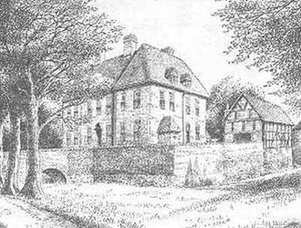
Kingshurst Hall was an 18th-century house, it was the home of the de Montfort family. The building was demolished in 1962, some of its bricks being used to repair the bridge - picture drawn in the 1940's.
Thanks for the use of this image to E W Green, Historic Buildings in Pen & Ink - The Work of William Albert Green.
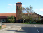
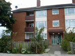
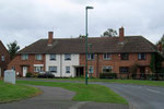
Although it lay beyond the city boundary, the Kingshurst Hall estate was developed by Birmingham City Council for housing during the 1960s. It is a clearly defined residential district west of Yorkswood between the Chester Road and the River Cole east of Cooks Lane. There is a substantial number of earlier private houses in the area as well a large number of council houses. The centre of Kingshurst dates from the 1960s and is located around Marston Drive/ Gilson Way where there are shops, a library and St Barnabas' Church. The shopping centre is to be redeveloped in 2020.
Click to enlarge the images in the Kingshurst Gallery below.


William Dargue 25.10.08/ 07.12.2020
For 19th-century Ordnance Survey maps of Birmingham go to British History Online.
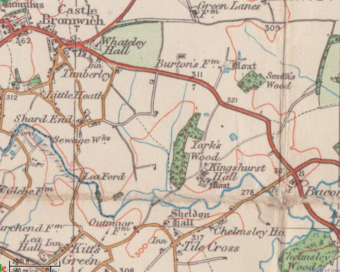
Map below reproduced from Andrew Rowbottom’s website of Old Ordnance Survey maps Popular Edition, Birmingham 1921. Click the map to link to that website.