William Dargue A History of BIRMINGHAM Places & Placenames from A to Y
Hay Mills
B10/ B25 - Grid reference SP115848
Haye: first record 1171; Hayemill 1495
Old English gehaeg means 'fenced/ hedged land'. Here would have been the farm of a medieval family who had enclosed some of the fertile land near the River Cole. The enclosed fields may have been surrounded by a substantial ditch perhaps as wide as two metres and over a metre in depth. There would have been a corresponding bank of similar dimensions. It is likely that the bank was topped with a fence while a live hedge grew. The hedge would have been planted with hawthorn, a quick growing tree whose name literally means 'hedge thorn'. It is likely that the enclosures would have been used for keeping livestock, probably cattle, close to the lush watermeadows along the river. Hugh de la Haye, his family name taken from the placename, is recorded in 1171.
Well worth a look - Hay Hall.

Still standing on Redfern Road is the medieval Hay Hall which may mark the Anglo-Saxon site. This Grade II Listed building was a sub-manor house of Yardley and is a surprising anomaly in an industrial area.
Standing on a moated site near the confluence of Sparkbrook and the River Cole at Tyseley, the hall was probably built by Robert de la Hay c1300. In 1423 the hall came into the Este family when Marion, the last of the de la Hays married Thomas Este, the governor of Kenilworth Castle.
The house was extended in Tudor times, and the front (originally the rear) was rebuilt after a fire in 1810 in a Georgian neo-classical style. The house belongs to an industrial firm and, although part of it may be seen fronting the road, it is not accessible without permission
Unfortunately the former front cannot be seen from the road. The hall owes its present state of preservation to the 1948 restoration when it was put to its present use as offices for Reynolds
Tubes. A small museum includes a piece of stained glass bearing the initials A E, thought to be those of Anne Est who married Edward Gibbons in 1538.

Hay Mill
The district takes its name from Hay Mill which stood on the River Cole near James Road/ Mill Road. The mill belonged to the occupants of Hay Hall and ground corn from at least 1495. Converted to blade grinding probably during the Civil War, this trade continued until about 1830 when James Horsfall, a wire drawer of Digbeth moved here. He had the old buildings demolished and rebuilt some 100m north of the old site. Here a larger mill with a larger pool was built for wire drawing.
In 1853 Horsfall patented a process of heat treatment which produced a wire with twice the tensile strength of conventional wire. That same year he merged his company with that of Joseph Webster of Penns Mill, Sutton Coldfield whose speciality was in producing piano wire for which he had a major export market in Europe. Subsequently the company virtually monopolised the market in piano wire. Webster & Horsfall's high-tensile wire also was used for making needles, fishhooks and umbrella frames and many other items.
The firm made the wire for first successful transatlantic telegraph cable laid by the Great Eastern in 1866, using 30 000 miles of wire weighing 1600 tons and made by 250 workers in less than a
year. It was the company's largest order and remained so for another 100 years. The mill works expanded along the river with the 1830 building being demolished and replaced by 1900. Steam was
increasingly used to supplement water power which was nonetheless still used for some processes as late as 1914. The company is still going strong on the same site and now specialises in the
production of springs.
During the 1920s the Tyseley Refuse Works was built and most of the watercourses were destroyed although traces of the original millpool still survive.

Take a look - St Cyprian's Church.
James Horsfall was typical of many wealthy Victorian industrialists and took his responsibilities to his workers seriously. Begun in the schoolroom on The Fordrough in 1864 as a mission church of
Yardley, a new church was paid for by Horsfall and dedicated to St Cyprian with St Chad. It was designed in gothic style in red and blue brick by Martin & Chamberlain, appropriately
built over the mill leat and consecrated in 1873. That same year a school was set up for the children of the mill workers, known by 1877 as St Cyprian's Church School. The small brick
building with its simple pointed gothic windows still stands. Transferred to Yardley School Board in 1892, it closed when Redhill Board School opened that same year.
The Coventry Road which runs through Hay Mills has been an important regional highway from Norman times and became the more so from the Middle Ages for Birmingham's merchants to gain access to
London. Hemill Bridge across the River Cole is shown in John Ogilby's 'Britannia' of 1675, at this time probably a footbridge alongside the ford. The Coventry Turnpike was laid out in
1745. However, William Hutton was to write nearly forty years later:
To Coventry, about twenty [miles] can only be equalled by the Dudley Road. The genius of the age has forgot to accommodate the foot passenger with a causeway.

Hay Mills tollgate
A tollgate stood at the Cole crossing where a bridge across the river was later built. In 1820 the Coventry Road was improved by Thomas Telford as part of the London-Holyhead Mail Road.
A new road bridge over the river was built and the tailrace of Hay Mill was crossed by a small humped bridge which was replaced only after waterpower was abandoned in 1914. Telford also abandoned the Red Hill holloway, impassable clay in winter, for a new metalled route alongside. The Coventry Road was disturnpiked in 1872.
Image left:Hay Mills former tollhouse. Image from the Acocks Green History Society website, reuse permitted for non-commercial or educational purposes.

There was no settlement at Hay Mills in 1834, but by 1888 the south side of the Coventry Road was being built up from Heybarnes Road to Forest Road. By 1906 there was considerable urbanisation, although Hay Mills was still separated from Small Heath by the undeveloped Cole valley.
The urbanisation of the area was strongly influenced by the continuing expansion of the Webster & Horsfall wire-works with the remaining farmland developed soon after World War 1.
Hay Mills is now largely a working-class suburb with much industry and dominated by the swathe cut through it by the Coventry Road which was expanded to six lanes in the 1990s.
William Dargue 21.03.2009/ 26.11.2020
For 19th-century Ordnance Survey maps of Birmingham go to British History Online.
http://www.british-history.ac.uk/mapsheet.aspx?compid=55193&sheetid=10104&zm=2&x=82&y=267&ox=631&oy=2054.
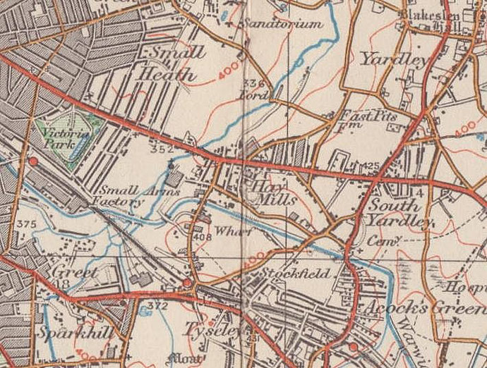
Map below reproduced from Andrew Rowbottom’s website of Old Ordnance Survey maps Popular Edition, Birmingham 1921. Click the map to link to that website.