William Dargue A History of BIRMINGHAM Places & Placenames from A to Y
Hawkesley, Hawkesley End - West Heath
B38 - Grid reference SP045775
Hawkesley Hall, or simply Hawkesley, stood at Hawkesley End in West Heath, in the Headley Yield of the parish of Kings Norton. A surviving pond may be the remains of the hall's medieval moat. The farm was also known as Little Hawkeslow/e, Little Hawkesley or Lower Hawkesley, the implication perhaps being that Hawkesley House near Longbridge was Great Hawkesley. The relationship between the two Hawkesleys is, however, uncertain. It seems certain that Hawkesley near Longbridge was the site of the Civil War siege. However, the Middlemores also have a long history in Kings Norton and it may be that this Hawkesley in Kings Norton was their first residence.
James Sherriff's 1798 map of 25 miles round Birmingham records the name as Hawkswell though it is not cerftain from the map to which Hawkesley he is referring.
The Domesday Book entry for Bromgrove includes 18 outlying berewicks or sub-manors, one of which is Kings Norton. It also mentions the presence of 4 hawks' eyries. Whilst it does not specify where the eyries were located, it may be that one or more or all were at Hawkesley, hence the placename.
Richard de Hawkeslow was assessed for tax in Bromsgrove and Kings Norton in 1280. Sometime before 1424 John Hawkeslow granted seven messuages ie. houses and land in Kings Norton to Humphrey Stafford, an estate which was later described as 'the manor of Hawkelowes'. The estate was sold before 1549 to one of the Middlemore family, probably William Middlemore whose son John held the manor in 1553. The house continued in the possession of the Middlemores until after the English Civil War.
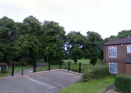
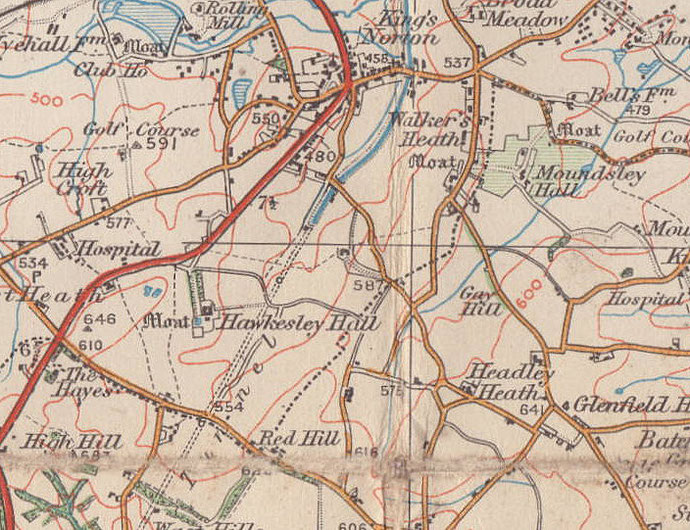
Hawkesley Hall moated site
Some 10 metres wide, Hawkesley Hall’s moat surrounded an almost square island with sides of about 36 metres on which stood the hall. About 1850 the old hall, almost certainly timber-framed, was demolished, the moat filled in and a new house built on the site.
This was demolished in the 1950s ahead of the new municipal housing estate. A hollow is the site of a former pond, possibly the remnants of the moat. Ridge and furrow north of hall was built over. However, the site of the hall was left as a public open space. Many of the trees here date from the landscaping of the gardens around the Victorian house. A footpath was laid in 2007 along the route of the infilled moat.
There had been some council building here in the early 1950s, including the construction of blocks of flats. However, this was still largely a rural area until 1972 when Birmingham was given permission to expand its borders into Worcestershire and create a municipal housing estate bordered by the Redditch Road and Longdales Road.
By the end of the 20th century the municipal estates of Hawkesley, Pool Farm and Primrose Hill were suffering from neglect. The housing stock had deteriorated and there were problems of crime and anti-social behaviour. Clearly a single geographical unit, they were designated at the beginning of the 21st century ‘The Three Estates' and a concerted plan of action has been put in place to improve conditions there.
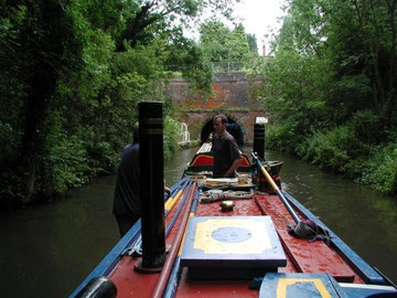
Take a look. The Worcester & Birmingham Canal which opened in 1815 leaves Birmingham from Gas Street Basin and passes beneath the Hawkesley estate. Twenty-three years in the building, the canal took coal and industrial products south and brought grain, farm produce and building materials to Birmingham.
Pairs of donkeys rather than a single horse were usually used to tow narrow boats on this canal - it is thought that this may have been so that the smaller donkeys could be taken on board while the boatmen legged the craft through the Wast Hill Tunnel which runs some 2500m under Hawkesley and emerges before Bridge 69.
The tunnel, which opened in 1796, is the longest on the canal and one of the longest on any British canal. It was built in broad gauge. The original intention had been to build the
whole canal in this gauge but this proved to be too expensive.
The tunnel has no towpath. With the canal here being broad gauge, it may be that the current technology did not allow for a wider tunnel to accommodate a towpath. Horses had to walk over the hill (some of the path can be still seen at the Hopwood end) while the boats were legged through. From the 1870s steam and subsequently diesel-powered tugs were used.
William Dargue 23.09.2008/ 23.10.2016
For 19th-century Ordnance Survey maps of Birmingham go to British History Online.
Map below reproduced from Andrew Rowbottom’s website of Old Ordnance Survey maps Popular Edition, Birmingham 1921. Click the map to link to that website.