

William Dargue A History of BIRMINGHAM Places & Placenames from A to Y
Hamstead
B20/ B42 - Grid reference SP046931
Hamstede: first record 1213

Sometimes recorded as Hampstead, the area lay within the ancient parish of Handsworth. Ham stede may simply mean 'homestead' in Anglo-Saxon, this one near an important crossing of the River Tame. However, the Old English term hamm means 'land within the loop of a river', and this is certainly applicable here. The soil in this river valley would have been high in alluvial content providing good pasture for livestock as well as fertile soil for growing crops.
Hamstead End was one of the eight administrative districts of medieval Handsworth.
In 1538 William Wyrley held freehold of the manor of Handsworth his chief mansion called Wyrleys or Hamstead Hall and all lands belonging to it, as well as other properties called Holford and
Milwards, Hamstead Mill and Holford Mill, a fishery on the River Tame, and other lands besides.
William Wyrley's hall was the original manor house of Handsworth, but it is not known when the Wyrleys first came into possession of the house or estates. Certainly the family is known from at least the 13th century holding land in Hamstead, Handsworth, Little Barr and Perry. The hall and its estates along with half the manor of Perry and the manor of Handsworth passed to the Wyrleys' descendants, the Birches in the 18th century.
Hamstead Hall
The manor house stood at the junction of Hamstead Hall Avenue and Beauchamp Avenue and this may have been the site of the Anglo-Saxon homestead. Hamstead Hall stood here until the 18th century when it was demolished to be replaced by a new Hamstead Hall near Acfold Road.

Charles Pye wrote (of the new hall) in 1818:
Hamstead hall . . . is a very elegant and modern-built mansion, the old one having been taken down some years since, which was for many generations the seat of the ancient and respectable family of the Wyrleys, who possessed the manor and very large property in this parish. . . .
It is difficult to conceive a more beautiful residence than this, as it contains all that hill and dale, wood and water, aided by extensive views, can do, to make a place delightful and
desirable: these seem here to have been combined in the most beautiful manner; for the river Tame meanders through this enchanting and extensive domain; on whose banks are numerous groves of
trees, and from a solid rock there arises a lime tree, of unusual magnitude, whose branches spreading in an horizontal direction became so heavy, and injured the trunk to such a degree, that in
order to preserve the body, it not only became necessary to lop off the principal branches, but to bind it together with iron in different ways, by hooping of it, and passing a bar of iron
through it, in the same manner as buildings are frequently done, to preserve them.
At the height of three feet, it girths twenty-three feet and rises to the height of seventy feet. The rock upon which this tree grows, is of such a nature, that there is a grotto of considerable size cut in it, wherein the roots from this tree spread themselves in different directions.
This new Handsworth manor house was demolished in 1935 and the site was later built over with housing. All that now remains is part of the walled garden wall which survives in woodland to the
rear Greenway and Croftway and the ruins of the hall's icehouse near the River Tame.
Handsworth's manorial mill, Hamstead Mill stood on the Tame north of the Old Walsall Road crossing of the river at Hamstead Hill. The manor was one of the few in Birmingham where
a mill was mentioned in the Domesday Book in 1086. The mill stood south of the river and was operated by Frank Andrews as a two-wheel mill driving four pairs of millstones and continuing to grind
corn until 1920. The buildings remained intact until 1960 when they were demolished. Samuel Botham's survey of 1794 recorded Windmill Hill at Elmbank Grove, but Hamstead windmill was long gone by
then, neither appearing on Browne's 1682 county map nor on Beighton's map surveyed between 1722 and 1725. The work of the windmill was probably transferred back to the watermill.
Iron founding
Small-scale iron founding had probably begun in this area as early as the 15th century, but it is in the 16th century that the activity first appears in the records. Although the iron ore was
mined in the Black Country, timber to make charcoal for the smelting process was already scarce in that area and some industry consequently relocated to the Tame valley where wood and water-power
were more readily available.
The earliest sites to be recorded are an iron bloomery forge at nearby Perry in 1538 and in 1548 an iron hammer mill at Handsworth. Blast furnaces, which used water power to drive the bellows,
were often situated on side-streams, while finery forges which needed more water to raise the heavy tilt-hammers were usually built on the main river, in this case the Tame. By the 18th century
there was a blast furnace here which was known as Hamstead Forge; it had closed by the end of the century.
Birmingham's first historian, William Hutton was not impressed with the (Old) Walsall Turnpike which had opened in 1727. He stated in 1781 that 'the road to Walsall, ten miles, is rather below
indifferent.' However, the Old River Tame bridge, which had been built in the late-18th-century, must have been a great improvement. The bridge, which is Grade II Listed and now takes only
pedestrians, has balustrades which were added in the 19th century.

Although there were coal mines nearby in the Black Country, part of the South Staffordshire coalfield, Hamstead Colliery was the only mine within the City boundary. The minehead occupied a site south of Hamstead Road west of its junction Spouthouse Lane.
Following successful mining at nearby Sandwell Park, the Hamstead Colliery Company was formed in 1875. 200 hectares of land were leased from G C Calthorpe of Perry Hall and the following year shafts were sunk.
Because of unexpected geology and problems with flooding, the first coal was not brought up commercially for another two years. Coal was mined here from the thick seams at a depth of some 600 metres, at that time the deepest coal mine in the world. A light railway ran due north to a basin on the Tame Valley Canal along which the coal was shipped.
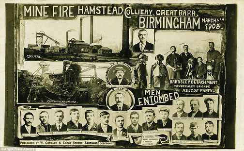
Hamstead Colliery fire
In 1908 a fire broke out in the mine which led to the deaths of 25 men and 28 pit ponies. Plans are in hand to commemorate the dead with a statue near the site. The coal seams here were considered uneconomic after World War 2 and when the mine closed in 1965, the site was later developed for housing. It is, however, believed that some 4.5 million tonnes of coal still remain in the mine.
Hamstead Station opened on the Grand Junction Railway (Birmingham-Liverpool) known as Great Barr station on the west side of the Old Walsall Road bridge. It retained the name until the station was rebuilt on the other side of the bridge.
A working-class hamlet grew up on the Old Walsall Road near Hamstead railway station during the 1870s and by 1885 there were a number of large houses in extensive grounds around the junction of
the Old Walsall Road with Spouthouse Lane and on the (New) Walsall Road. but it was not until the 20th century that widespread building began. Much of Hamstead now lies in West Bromwich in the
Metropolitan District of Sandwell.
From the 1930s private housing was built on the Birmingham side on the estate of Hamstead Hall and on the farmlands of Hamstead Mill Farm and Cherry Orchard Farm west of Hamstead Hill.
See Cherry Orchard.
William Dargue 15.03.2009
For 19th-century Ordnance Survey maps of Birmingham go to British History Online.
Map below reproduced from Andrew Rowbottom’s website of Old Ordnance Survey maps Popular Edition, Birmingham 1921. Click the map to link to that website.
