

Wylde Green
B72/ B73 - Grid reference SP125945
le Wylde: first record 1537

Wylde Green lies in the south of Sutton Coldfield. 'Wild' probably derives from wild meaning 'uncultivated/ desolate'; in the 16th century it was known as le Wylde ie. The Wild. However, there is a similar Old English word which means machinery of some kind, possibly a windmill? A green in the Middle Ages was usually open pasture used by the community; the area was enclosed in 1825.
The 1834 One-Inch Ordnance Survey map shows Wild Green House on the Birmingham Road opposite Station Road. Was this the site of the original green? Certainly the area was later defined by the siting and naming of Wylde Green railway station on the Sutton Coldfield Branch Line from Birmingham in 1862. After the enclosures of 1825 the population gradually increased, and in 1840 Wylde Green School was founded catering for some 60 pupils.
Take a look. Two Grade II* Listed buildings survive on Wylde Green Road. At the east end, the barn range of New Shipton Farm has been dendro-chronologically dated to summer 1434
and spring 1435 and has 18th- and 19th- century additions. It is a rare survival with five pairs of cruck blades forming the frame and is internally impressive. (See Shipton.)
The Stone House is one of the few surviving Vesey houses built by Bishop Vesey in the early 16th-century. Built of sandstone in contrast to the timber-framed houses of the poor, this was originally the fordkeeper's cottage across the Ebrook or Plantsbrook on the main road from Sutton to Coleshill.

On the Birmingham Road at Marchmount Road Marchmount House was a square faced neo-classical-style house built in 1853 for Birmingham silverware manufacturer Henry Fielding. It was set back from the Birmingham Road and approached by a winding drive; there were extensive gardens and a horse paddock to the rear.
This and other large houses were demolished and the Woodlands Estate was built in the 1950s, covering the present roads of Marchmount Road, Hillcrest Road, Woodleigh Road, Britton Drive, Hilton Drive, Simpson Road, Oakhurst Road and Hawthorn Road.
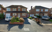
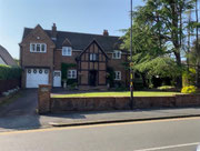
Even before the railway line to Sutton was completed in 1862, numbers of house plots in Highbridge Road and Station Road were laid out in 1858 in anticipation. In the later years of the 19th century a deal of good housing was built in the area prompted by the easy access by train into Birmingham. Much of the Victorian housing survives in good condition and ranges from provision for the very wealthy down to the middle class, the area having maintained its desirable status.

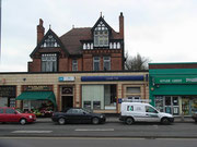
There was further residential development between the First and Second World War, but the greater part of the district was urbanised in the 1950s. many small shops on the Birmingham Road and the more recent Lanes shopping centre serve the district.
Take a look. Emmanuel Church was built from 1909-1916 by W H Bidlake and was named after the donor of the land, Emmanuel College cambridge. This is a tall narrow church built in
brick in early English gothic style. It has no tower but its polygonal all-glass apsidal chancel presents a striking face to the Birmingham Road where the busy local shopping centre is now
situated.
(See Gallery below.)

At the corner of Britwell Road and Highbridge Road, Wylde Green Congregational Church was built in gothic style in 1904 to replace an iron church of c1900; a hall was added in
1933 and further accommodation 1975 on the site of the original temporary building. The church became Wylde Green United Reformed Church in 1972.
Click to enlarge the pictures in the gallery below.


William Dargue 05.02.09/ 21.01.2021
For 19th-century Ordnance Survey maps of Birmingham go to British History Online.
Map below reproduced from Andrew Rowbottom’s website of Old Ordnance Survey maps Popular Edition, Birmingham 1921. Click the map to link to that website.
