

Stechford
B33 - Grid reference SP130873
First record: Sticheford 1249, Stechford 1844

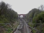
The modern district of Stechford covers a wide area north of Yardley, of which manor it formed the western part, and east of the River Cole, which marked the boundary with the manor of Castle Bromwich. The first recorded version of the name Sticheford, however, derives from the Old English styfic ford perhaps meaning 'stump ford'.
However, the name may refer to a 'sticky ford', one where clay underfoot and a poor crossing was to be expected. The first reference to Stycheford Bridge is recorded in 1497 though a bridge
here could well have been in place during the previous century. This is likely to have been a wooden pedestrian bridge alongside the ford which was used by livestock and wheeled vehicles. In 1895
the bridge was rebuilt jointly by Warwickshire and Worcestershire County Councils and Birmingham City Council.
As a placename Stechford referred only to a tiny settlement near the river crossing. William Hutton described Stichford in 1783 as 'only a pitiful hamlet of a dozen houses'. When
Stechford railway station was opened on the London & Birmingham line in 1844, the focus of the village moved to the area around the station and the misspelt station name,
Stechford came into use.
The small shopping centre at the top of Albert Road which was once known as Five Ways, is now referred to as Stechford Village.

The ford here is part of an ancient local route from the crossing of the River Cole at Trittiford in Yardley Wood. This splits at Yardley Road. One branch takes the high road along the Yardley ridge via Church Road to the ford at Cole Hall Lane to meet the Chester Road at Castle Bromwich; the other follows the valley of Stich Brook along Stoney Lane to the Cole crossing at Stechford Lane before going on to Bromford.
Evidence of the Bronze Age
In 1939 just months after the Second World War had begun, Mr C L Schramm was digging in his garden in Flaxley Road to lay the foundations of an air-raid shelter. His spade hit a metal object of unusual shape which he cleaned and subsequently took to Birmingham Museum. Measuring 16cm in length and made of bronze, it was identified by the experts as a palstave some 2000 years old and dating from the Middle Bronze Age. A palstave is a type of axe shaped to fit into a split handle into which it would be bound with leather strips, rather than being perforated with a socket in the axe for the handle to fit into. Such an object is a rare find in this area. It suggests that the lighter soils here may have been cultivated a thousand years before the Anglo-Saxons named this area Flaxley, 'flax clearing'.
A number of 3rd-century Roman coins have been found at a depth of one metre in Webbcroft Road and another coin in Victoria Road on an allotment, a site which has since been built over.
In medieval times this area was part of the Yardley system of open fields. Yardley Fields Road divided the Yardley Fields in two: Church Field to the south and Stichford Field, of which Albert
Road was a boundary track. A small park on Yardley Fields Road is still open land.

The power of the River Cole was harnessed in the Middle Ages by Stechford Mill which stood on the north side of the river above Stechford Bridge. First recorded as a corn mill in 1249 owned by Giles de Erdington, lord of that manor, the mill was rebuilt and the pool enlarged in the 18th-century when blades were ground here. It survived until c1840 being finally used for paper making. The present balancing lakes were dug for flood prevention during the mid-20th century and may reflect the earlier watercourses. Although the mill itself is not shown on 19th-century Ordnance Survey maps, the mill house survived until 1929.
By the early 19th century (Lower) Stichford was a hamlet in the north-western corner of the large manor of Yardley. It centred on the triangle between Station Road, Flaxley Road and Iron Lane
with an inn, the Bulls Head, and a smithy east of the Cole bridge.
Upper Stichford was an even smaller hamlet on the other side, the west bank of the River Cole on the borders of Little Bromwich and Castle Bromwich manors.

With the opening of the railway station in 1844 the focus of development moved uphill. In the 1870s Frederick Road, Victoria Road and Albert Road were laid out near the station. Most of the new residents were from Birmingham, middle-class businessmen or managers and many had live-in servants.
By 1906 Francis Road, Lyttleton Road and Manor Road were under development and there was building at the top of Yardley Fields Road where Five Ways was named. At this time Stechford was a rural commuter village, the nearest urban areas being Saltley, Bordesley Green and Little Bromwich.

By the end of the 19th century Victorian Stechford had developed along Station Road and Albert Road with a village centre at Five Ways. Many Victorian houses survive as does All Saints' Church. Founded as an iron mission church of St Edburgha's in 1877, the present building in red brick and terracotta was designed in decorated gothic style in 1898 by J A Chatwin. It was not consecrated until 1932, shortly after which an apsidal baptistery and porch were added from the original design.
Although it has no tower, it is a similar design to Chatwin's St Mark's at Washwood Heath. Stechford School at the top of Albert Road was opened in 1894 by Yardley School Board in All Saints' Church Sunday School. The present building was erected at Five Ways in 1896 and enlarged in 1906.
The city's last major tram route opened to Stechford in 1924 with the beginning of major housing development. There was a mixture of private housing (eg. around Flaxley Road) and council housing
(eg. Glebe Farm estate). Corpus Christi Roman Catholic Church opened to cater for the new population, many of whom were moving
from central districts of the city, and the Roman Catholic church school was set up in 1934 initially in the chapel buildings.
Building continued as late as the 1960s with an estate around Red House Road. Further small estates were built in the 1980s on what had been Flaxley, the playing fields of Saltley College, and off Old Farm Road on the site of Hill House Farm.
See also Lower Stechford and Upper Stechford.


Stechford Hall
A large mansion was built in the mid-19th century between Coleshill Road and Stechford Lane was named Stechford Hall. However the River Cole is the boundary between Yardley, of which Stechford was part, and the house was actually at the very west end of Castle Bromwich. Stechford Lane marks the boundary with Little Bromwich. This article should probably be included with Hodge Hill.
It is possible that Stechford Hall had a Georgian predecessor: Tomlinson's map of 1759 seems to show building here. The Victorian house was designed by the Castle Bromwich architect J J Bateman (1817-1903) and may have been built for Joseph Smallwood of Perry Barr sometime after 1854. His wife Sarah died at the house in 1869. Joseph, aged 59, was still living at Stechford Hall at the time of the 1881 Census with his youngest daughter and oldest son, also Joseph. Both are described as wine merchants and Justices of the Peace. Also listed are a butler, a cook and three servants. However, ten years later the family had moved to Milverton near Leamington Spa.
In 1903 the death was recorded of merchant William George Hills whose address is given as Great George Street, Birmingham and Stechford Hall.
It may be that the house then became vacant, for in 1910 Sister Marie de St Pierre of the Tyburn Convent in London wrote to Edward Ilsley, the Roman Catholic Bishop of Birmingham hoping to establish a convent at Stechford Hall. She intended to come to Birmingham to meet the Bishop. The plans never materialised, for about 1912 the hall was leased by All Saints Mental Hospital as an annexe. Stechford Hall is shown on the 1921 Ordnance Survey map still surrounded by fields at that date.

Much of the area was built with private housing between the two world wars as can be seen from the aerial photograph below published in the Birmingham Weekly Post and dating from about 1949. It is courtesy of Robert Darlaston’s website - see Acknowledgements for a link. The text below is from Robert Darlaston's website:
In the left foreground is the Washwood Heath Road with trams on their reserved track. Alum Rock Road merges in the right foreground. The Beaufort Cinema is just above and right of the traffic island.
The Outer Circle route crosses from left to right and Coleshill Road continues into the distance toward Hodge Hill Common, just visible where Coleshill Road bends left into the trees.
The sand quarry is visible right of centre: it was later filled in and became Stechford Hall Park.
Rural Castle Bromwich stretches across the top of the photograph.
William Dargue 07.03.09/ 10.01.2021
For 19th-century Ordnance Survey maps of Birmingham go to British History Online.
Map below reproduced from Andrew Rowbottom’s website of Old Ordnance Survey maps Popular Edition, Birmingham 1921. Click the map to link to that website.
