

Selly
formerly in Worcestershire - one of the Domesday manors of Birmingham
Selly Oak, Selly Cross
B29 - Grid reference SP041824
Escelie: first record in the Domesday Book 1086, Selly Oak, Sally Oak late 18th century
See also Selly Park.

Covering a much wider area than the present district of Selly Oak, the Anglo-Saxon manor of Selly lay within the bounds of Merritts Brook, the River Bourn and Icknield Street.
It appears in the Domesday Book as Escelie and was divided into sub-manors in the possession of William Fitz Ansculf of Dudley with Bartley (Green) a berewick or sub-manor.
The sheriff of Warwick was Wulfwin, an Anglo-Saxon who had held one of these manors before 1066; he also owned the manors of Birmingham and Frankley. Wulfwin bequeathed his estates to his wife and on her death to the Church, but this was not to be.
After the Conquest King William replaced most of the Anglo-Saxon lords with his Norman supporters, in this case Wibert. Wulfwin was dispossessed. In common with many manors, the upheaval of the Conquest caused Selly to decrease in value by the time the Domesday Book was compiled. However, at 75 shillings, this was still one of the area's more valuable manors. Selly later came within the manor of Northfield & Weoley.

Escelie is a topographical name from Old English scylf leah meaning 'shelf clearing' ie. 'the clearing on a shelf (of land)'. This probably refers to the flat top of the hill on glacial drift around the junction of the Bristol Road with Oak Tree Lane.
The 'Oak' element is uncertain but may derive from the 14th-century Selly Soke, the latter term referring to a manor granted certain powers of jurisdiction. The name is recorded by the 1790s as Selly Oak.
Selly Oak is located at the crossroads of two important routes of ancient origin. The modern Bristol Road is the descendant of a Roman road running from the south-west of England to the north-east. It is crossed here by an ancient local route, Oak Tree Lane/ Harborne Lane from Kings Norton to Harborne. This junction is recorded as Selly Cross in 1506.

Well worth a visit - Selly Manor
Selly Manor originally stood on Selly Hill near the junction of Bournbrook Road with Rookery Road. It is known to have stood there in the 15th century, probably built by the Jouette family who
were local tax collectors, known at that time as the lords of the tithing. The house was extended in the Tudor period.
However the name Selly Manor is a misnomer: the house never was the manor house of Selly. That is thought to have stood on a moated site north-west of Five Gates Farm, now the maintenance depot of Bournville Village Trust in Willow Road. The moat, which was built over about 1900 with the building of the Bournville estate, was not the usual rectangular or square shape typical of medieval moats. It may well have been a prehistoric moated enclosure reused by the lords of Selly manor.
However, by the late 19th century its earlier status was long gone and it was being rented out as three separate lodgings, known as The Rookeries, and falling into disrepair. With the rapid development in the district of terraced rows the house was due to be demolished. George Cadbury decided to save it by having it removed in 1907 to Bournville village green.
Taken down piece by piece from 1912, it was to be over four years before the house was opened to the public in its new location. The house is now a museum owned by Bournville Village Trust and open to the public. See also Bournbrook.


The Selly Oak
The centre of the district is the junction of Oak Tree Lane and the Bristol Road where the 'original' Selly oak tree stood. This may have been a tree planted by John Rodway in what were then the grounds of his Selly Oak House in 1830 to celebrate the coronation of William IV. However, dendrochronological dating of the stump gave a date of 1710-1720 for the tree. In 1909 the dying tree had to be felled, its roots damaged by the building of the nearby houses, now converted into shops. The tree stump was ceremonially placed in Selly Oak Park where Kings Norton and Northfield Urban District Council placed a plaque which read, 'Butt of Old Oak Tree from which the name of Selly Oak was derived. Removed from Oak Tree Lane, Selly Oak 1909'. The remains of both stump and plaque may still be found. A new oak tree was planted c2000 on Oak Tree Lane, a plaque noting it as a replacement for the old oak.
It may be that when the Bristol Road was turnpiked in 1727, the oak tree became a landmark at the crossroads with Oak Tree Lane/ Harborne Lane, leading to the addition of oak to the placename. At that time there was nothing more than a tiny hamlet around the junction.
Left: Oil painting of 'The Old Selly-Oak Tree' by W Stone 1897. The painting was made for the brewer William Butler (later of Mitchell & Butlers Ltd), and hung in the old Oak Inn in Selly Oak. This photograph was taken at the 'Antiques for Everyone Fair' at the National Exhibition Centre, Birmingham April 2005 and is believed by Wikipedia to have no copyright restrictions. Image uploaded to Wikipedia by Lepidus Magnus.
Scant but definite evidence points to the presence of people in Selly Oak over five thousand years ago. In 1995 a small piece of neolithic worked flint was found at St Mary's Hospice in Raddlebarn Road, and near the River Rea at Dogpool Lane in Selly Park the blackened pebbles of a burnt mound are mysterious evidence of the Bronze Age. Excavations in the grounds of the hospice have also yielded a fragment of Iron Age pottery some two thousand years old.

The Roman road - but where?
Somewhere in Selly Oak three Roman roads met - but where? The road from Alcester (known by its medieval name as Icknield Street) crossed the Rea at Lifford to follow the Pershore Road from Breedon Cross as far as Bournville Lane. Thereafter its route unknown.
The road from Droitwich crossed the Lickey Hills to run close and parallel to the Bristol Road South after which its route is also unknown. Both roads certainly headed in the direction of Metchley fort in Edgbaston.
And the third road was the northward continuation of the other two. Also known as Icknield Street, it linked Metchley with the Roman fort at Wall near Lichfield and the north-east of England. Its route through Sutton Park is well known, but its route through the city is unknown.
The junction of these roads may have been at Selly Park Recreation Ground where, despite extensive research, no evidence has been found. However, physical evidence in Selly of 400 years of Roman occupation are a coin of Constantine I (306-337) found in Frederick Road, Selly Oak and a Roman spindle whorl from Raddlebarn Road in Selly Park.
The construction of the Worcester & Birmingham Canal had a major impact on Selly Oak. Work began at Gas Street Basin in 1792, the cut reaching Selly Oak soon afterwards, but
it was to be another twenty-three years before the line was completed to Worcester. The canal took coal and industrial products south and brought grain, farm produce and building materials to
Birmingham. Salt was transported from Droitwich from the 1830s and from the early 20th century Cadburys brought the raw ingredients for chocolate-making to their Bournville wharf. Prior to the
introduction of self-propelled boats, pairs of donkeys were used for towing rather than the more usual single horse. The reason for this is unknown.
In 1798 the Dudley No.2 Canal opened to provide a lock-free route from the Dudley No.1 Canal to the Worcester Canal at Selly Oak. This bypassed the congested canals of central Birmingham and
became an important long-haul route between the Black Country and the South; The canal closed due to a roof fall in the Lapal Tunnel in 1917 which was held to be uneconomic to repair.
No visible traces now remain of the canal junction which was on the west side of the Worcester Canal alongside Battery Park. However, a water-filled stetch of the canal itself can still be seen
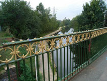
alongside Selly Oak Park. And despite the fact that the canal closed over a hundred years ago, Harborne Lane still crosses it via Harborne Bridge.
Because of easy access to the canal system industries began to develop including Sturge's phosphorous factory established on Elliott Road in 1793 alongside the canal. In 1853 this became
Elliott's Metal Company which was taken over by ICI in 1928. Most of the original buildings have since been demolished. Industry needs workers and workers need homes. While there was never a
village centre at Selly Oak, by 1834 there was a small settlement had developed here. A further spur to development was the laying of the Birmingham West Suburban Railway in 1876 and the opening
of Selly Oak Station. This line was built in co-operation with the Worcester & Birmingham Canal and was used from 1885 as a circular commuter route from Birmingham to Lifford and back to New
Street along the Birmingham & Gloucester line.
Click on the canal images below to enlarge.


By the beginning of the 20th century Selly Oak was an important road, canal and rail intersection and became increasingly industrialised and built up with working-class housing between Dawlish Road and Exeter Road, north of Gleave Road and around Chapel Lane. Houses were converted into shops along the Bristol Road and Oak Tree Lane. By 1906 Selly Oak and Selly Park had spread westwards to the Bournbrook valley, eastwards to the River Rea and southwards to Bournville. However, even at this date Selly Oak remained physically separate from Birmingham with countryside between.
The population of Selly Oak, which then included the small scattered population of Bournville, increased from some ten thousand residents in 1891 to over thirty-one thousand by 1911, the date at
which Selly Oak residents voted to become part of Birmingham. The district is largely a creation of the late-Victorian and Edwardian period and much good housing survives here from that time. A
landmark on the Bristol Road near George Road is the gothic pumping station. It was built in 1878 to house a Boulton & Watt steam engine pumping water for domestic use from a borehole underneath
the building.

Take a look at St Mary's Church, built on Lodge Hill Road close to the centre of Selly Oak on land given by Joseph Ledsham, lord of the manor of Northfield. Standing prominently on the hill, this Grade II Listed church was designed in the decorated gothic style by the Birmingham architect Edward Holmes whose wife Ann is commemorated by a stained glass window of The Resurrection of 1861 in the Lady Chapel.
The construction uses two colours of sandstone, some of which was quarried at Weoley Castle. There is an interesting arrangement of the clerestory windows. St Mary's was consecrated in 1861 at a time when Selly Oak was developing as a compact settlement separated from Birmingham by several miles of countryside.
There are a number of stained glass windows given in memory of various members of the Elkington family, pioneers in electro-plating whose factory in Newhall Street was the home until c2000 of the Birmingham Museum of Science and Industry. George Elkington lived at Woodbrooke on the Bristol Road, now a college.
The church opened with a single bell by John Warner of London with five more were added in 1865. Some twenty years later the ring was augmented to eight with the addition of a new treble and a
twelve hundredweight tenor also by Warner in celebration of Queen Victoria's Jubilee in 1887. In common with most Birmingham towers, the bells here were recast with scientific tuning, these by
Gillett & Johnston of Croydon in 1932.
In 1941 during the Second World War a German incendiary bomb went through the roof and in 1959 extensive repairs also had to be undertaken to repair dry rot damage and repairs to the spire.
During this restoration the rood cross and beam beneath the chancel arch were removed; it was a time when Victorian tastes were very much out of vogue and part of a great decluttering. Other
modernisation included removing the high altar into the Lady Chapel and its replacement with an altar table; stained glass was removed from the chancel to allow in more light. There is a
traditional eagle lectern in oak stone, a panelled stone pulpit and in the baptistery an octagonal stone font designed by W Butterfield, its cover by the Bromsgrove Guild. Burials took place here
from the opening of the church, but the churchyard closed in 1899 when Lodge Hill Cemetery was opened, although burials continued in family graves until 1954. The Parks Department took control of
the churchyard from 1927.
An interesting development was the Selly Oak Institute set up in 1894 as a Quaker meeting house by George Cadbury. Later there was a gymnastics club, dance classes, social clubs
and choirs. The building, appropriately now an adult education centre, is timber-framed and designed in the arts & crafts style.

The Workhouse
At some time in the early 19th century, possibly earlier, Kings Norton had a workhouse built on the Old Square at the west end of Kings Norton Green. In 1836 the Kings Norton Poor Law Union was set up to cater for the parishes of Beoley, Edgbaston, Harborne & Smethwick, King's Norton and Northfield.
The workhouse on the Green was extended. In 1870, a new Kings Norton workhouse was built on the north side of Raddlebarn Road to the design of Edward Holmes. In 1897 an infirmary was built south-east of the workhouse.
The workhouse buildings were extended to the west in 1902 with a new entrance block, ward block, clothes store, sewing room, and a wood-chopping shed. In 1911 King's Norton Union amalgamated with the Birmingham and Aston unions to create a new Birmingham Union. The medical facilities of the workhouse became Selly Oak Hospital with the creation of the National Health Service in 1948.
The hospital closed in 2011 with services transferring to the newly-built Queen Elizabeth Hospital. The site was developed with housing from 2015.
Tiverton Road Council School was opened in 1906 by Kings Norton & Northfield Urban District Council with accommodation for 510 children; it was reorganised in 1931 for juniors and infants only. Accommodation was provided in Bournbrook Congregational Church 1952; in the same year the former St Wulstan's CofE School adjoining the site in Dawlish Road was taken over as an annexe. The school was renamed Tiverton County Primary School 1954.
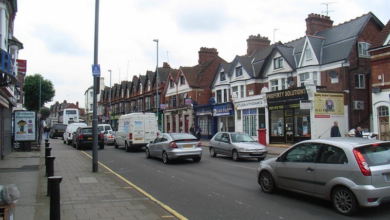
From the late 19th century Selly Oak was largely developed with working-class housing, mostly in terraces of small houses. Situated as it is adjacent to Birmingham University, it now houses a
substantial number of students in some 1500 houses. During ther second half of the 20th century Selly Oak has suffered from a planning blight. The Bristol Road is a dual carriageway almost from
the City Centre to Selly Oak and from Selly Oak southwards. Traffic congestion increased dramatically in the last years of the century to the point was the Bristol Road, the focus and main
shopping centre of the district, was becoming gridlocked. Uncertainty as to the outcome of various proposals was detrimental to the area. Work is now underway to by-pass the single-carriageway
part of the Bristol Road with a new road to the north and west of Selly Oak.
Selly Oak Gallery


William Dargue 10.03.2009/ 27.10.2012/ 07.01,2021
For 19th-century Ordnance Survey maps of Birmingham go to British History Online.
Map below reproduced from Andrew Rowbottom’s website of Old Ordnance Survey maps Popular Edition, Birmingham 1921. Click the map to link to that website.
