William Dargue A History of BIRMINGHAM Places & Placenames from A to Y
Rubery
B45 - Grid reference SO995773
Robery: first record 1650
First documented in the 17th century as Robery, from the nearby 'rough hill(s)', the name derives from the Old English ruh beorg or Middle English row berwe. Also written as 'Rowberrie', Rubery Hill is part of the Lickey Hills chain with Rednal Hill and Beacon Hill to the south, Frankley Hill to the north.
Until the 18th century this was considered part of Kings Norton waste ie. lands that were thought not to be worth cultivating. Rubery lay at the south western limit of Kings Norton manor, part of a sub-division called the Rednal Yield.
With no nucleated settlement here, this was an area of scattered farmsteads: Rubery Farm stood near the foot of the south-west slope of Rubery Hill on the site of Rubery Farm Grove, Rubery Hill Farm to the north-west of the hill near the junction of New Inns Lane and Cross Farms Lane. The name of Whetty/ Wetty Farm, originally Wetheye, suggests a medieval origin; it stood at the top end of School Road.
St Chjad;s Well
A holy well springs from the ground off Holywell Lane at the north end of Broadmoor Wood. This is a chalybeate spring, a word which derives from the Latin word for steel and is used to describe springs with a high mineral content which are generally rich in iron. Such springs were often considered as sacred from the earliest times and taken over as holy wells after the advent of Christianity. They may have been used for baptisms. This well has been dubbed St Chad’s Well; St Chad d.672, the Apostle of the Midlands has many places are associated with him, this one because he allegedly stopped to rest here while on his travels. It may be that the well was named by association with nearby Chadwich Manor/ Grange/ Farm, an estate listed in the Domesday Book as Celduic in the royal manor of Bromsgrove. However, this placename probably means Ceadwealla’s farm and has no association with the saint. Chadwich Manor and barns are listed buildings; the estate was given to the National Trust by the Cadbury family.
Whetty Coppice on Whetty Lane is 1.5 ha ancient semi-natural woodland. 'Ancient' is defined as pre-dating the year 1600; 'semi-natural' signifies that, though it has probably been managed economically eg. pollarded or coppiced, it has been left to regenerate naturally without human intervention. It is predominantly made up old hazel coppice with oak standards.
The Bromsgrove Turnpike from Birmingham was set up in 1727 roughly following the route of the modern Bristol Road. From Longbridge the road went via Lickey Road and up Rose Hill, following the route of the Roman road over the Lickey Hills.
William Hutton wrote of the turnpike road in 1781:
To Bromsgrove, thirteen miles, made extremely commodious for the first four, under the patronage of John Kettle, Esq; in 1772, at the expence of near 5000 l [pounds], but afterwards is so confined, that two horses cannot pass without danger; the sun and the wind are excluded, the rivers lie open to the stranger, and he travels through dirt ‘till Midsummer.
The Rose & Crown was a coaching inn which stood at Rednal near the foot of the dangerous ascent of the Lickey Hills. Probably built in Georgian times, the inn was a staging post where horses were changed ready for the steep climb up the hill. After 1880 a private house was built on the site of the inn, whose custom must have dropped dramatically with the opening of the new route. The house, which took the same name, is now a hotel.
In 1831 an easier route for coaches was made from Longbridge to Lydiate Ash, what is now the Bristol Road South, New Road Rubery and Birmingham Road; a coaching inn at Rubery was then opened and named the New Rose & Crown. The beginnings of a nucleated settlement at Rubery date from this time. The road was disturnpiked in 1872 when the Worcestershire county authorities took responsibility for the maintenance of highways.
Cock Hill is the north-south route along the west side of Rubery Hill. It presumably takes its name from the Cock Inn on Rubery Lane which was built in 1811.
Rubery Cuttings
By the early 19th century there were a number of quarries in the area, the last of which was in use until the late 1960s. There is sandstone here, but the main stone for extraction was the hard Lickey Hills quartzite laid down in the Cambrian period 570 million years ago. There were quarries on Rubery Hill itself and the quarry at Holly Hill had its own branch off the Halesowen railway.
At the junction of Leach Green Lane and the Bristol Road South, Rubery Cutting can be seen behind the shops and houses. Designated in 1991 as Local Nature Reserve exposed rock of the Rubery Sandstone Series can be seen.
The site is important for its early Silurian geology and is home to a wide range of small fossils, including corals, brachiopods, trilobites and graptolites.
Rubery, east of Callowbrook Lane and Newman Way, became part of Birmingham with Northfield in 1911; the western part remained in Worcestershire. The Birmingham side was developed for municipal
housing soon after the Second World War.
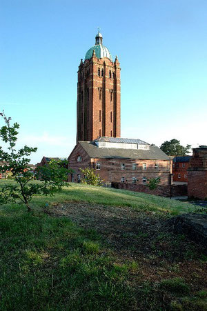
Off the Bristol Road South at Cock Hill Lane, Rubery Hill Hospital was formerly a lunatic asylum. It was built because Birmingham's Borough Asylum (now All Saints Hospital) at Winson Green was unable cope with an increasing number of patients some of whom came from outside the borough.
Still standing are the Medical Superintendent's House of 1879, the entrance lodge (now a private house) and the early-English-style chapel of 1882 by Martin & Chamberlain, again in use a church. All have 20th-century alterations and additions, but remain substantially Victorian and are Grade II Listed buildings.
See also Birmingham Great Park.
Right: Rubery Hill Hospital water tower © Copyright Andrew Clayton and licensed for reuse under Creative Commons Licence Attribution-Share Alike 2.0 Generic. Geograph OS reference SP0078.

Rubery Mission Church was built in 1895, its design modelled on a 15th-century timber church. The 17th-century farmhouse of Rubery Farm was used as the vicarage until it was demolished in 1970. A parish was created from The Lickey Parish in 1933.
In 1957 a new St Chad’s church was built, designed by the Wolverhampton practice of Lavender, Twentyman and Percy by Richard Twentyman.
Image left: Photograph by Roy Hughes 2009 on Geograph SO9877 reusable under Creative Commons licence Attribution-ShareAlike 2.0 Generic (CC BY-SA 2.0).
William Dargue 12.03.2009/ 30.08.2012
For 19th-century Ordnance Survey maps of Birmingham go to British History Online.
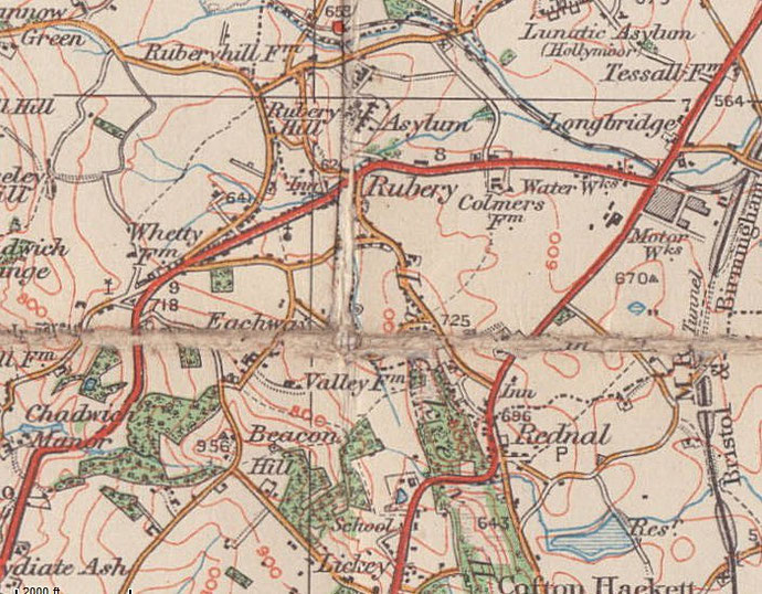
Map below reproduced from Andrew Rowbottom’s website of Old Ordnance Survey maps Popular Edition, Birmingham 1921. Click the map to link to that website.