

William Dargue A History of BIRMINGHAM Places & Placenames from A to Y
Lindsworth
formerly in Worcestershire - one of the Domesday manors of Birmingham
B14 - Grid reference SP060794
Lindwyrthe: first record 699, Lindeorde Domesday Book 1086
This name documents a site which has seen continuous occupation for over twelve centuries. Lindsworth Farm stood near the east end of Lindsworth Road until the early 20th century and gave its name to a street when housing took its place. There is no reason to doubt that this was the same site documented in the Kings Norton Charter of AD 699 which mapped out an estate around the River Rea. Lindsworth is recorded as one of the points on the boundary.
The perambulation of the estate appears to begin on the River Rea at Cartland Road:
thonne thaet cume in tha Geapan Linde, 'then it comes to the Spreading Lime Tree',
or possibly at Allens Croft Road/ Brandwood Park Road;
thonon thaet cume on Lindwyrthe; then it comes to Lindsworth, 'Lime Tree Enclosure/ Farm'.
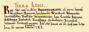
The Domesday Book records King William's possession of Bromsgrove with its eighteen outlying manors including Moseley, (Kings) Norton, Lindsworth, and others. They were all held by Earl Edwin, Lord of Mercia in the time of King Edward. Subsequently Lindsworth was subsumed within the manor Kings Norton.
William Dargue 03.04.2009/ 27.10.2012