William Dargue A History of BIRMINGHAM Places & Placenames from A to Y
Lickey, Lickey Hills, Lickey Warren
B45 - Grid reference SO993754
la Lecheye, la Lekheye, la Lechay, Lekhaye: first record 1225

The origin of this name is uncertain. The second element very likely comes from Old English (ge)haeg meaning 'an enclosure'. The first element is uncertain, but may relate to nearby Leach Green.
The hamlet of Lickey is around the junction of Rose Hill and Monument Lane and is sometimes referred to as The Lickey. See also Rednal.
The Lickey Hills is the name given to two ridges of hills, a higher and a lower. The higher ridge includes Rose Hill, Beacon Hill and Stock Hill; the lower includes Rednal Hill, Bilberry Hill and Cofton Hill, The range is part of the main English watershed. Raindrops falling to the north of the watershed find their way to the North Sea; rain to the south helps to fill the Atlantic Ocean. Lickey is a still rural area though now with substantial suburban development and perhaps centres on the Warren Lane/ Rose Hill junction, although settlement has spread downhill towards Barnt Green.
The Lickey Hills have a complex geological history. The main rock is cambrian quartzite which has been up-faulted into later carboniferous and permian rocks. On Cofton Hill, however, can be found
older rock from the late precambrian formed some 1000 million years old and perhaps the oldest rock in the Midlands. At that time Britain was located at the South Pole, and this fine-grained
Barnt Green volcanic rock was deposited as millions of tonnes of volcanic ash, which became gradually compacted.
The main rock of the hills, Lickey quartzite is a soft sedimentary rock 500 million years old, the result of wind-blown desert conditions during the Cambrian Period. Darker quartzite on Bilberry Hill, however, shows signs of having been deposited as sand at the bottom of a shallow sea.

Image right: Bilberry Hill quarry within the Lickey Hills Country Park. Ordovician Lickey quartzite is folded into a recumbent fold with the fold axis running just below the top of the quarry face. Image by woody on Wikipedia reusable under Creative Commons licence Attribution-ShareAlike 3.0 Unported (CC BY-SA 3.0)
On Beacon Hill Keele clay was deposited in arid conditions during the Carboniferous Period by a river which ran into a shallow lake. Periods of increasing rainfall carried sand mixed with the clay into the lake.
The present rocks were formed as sediments on the bottom of that lake 300 million years ago. Above the golf-course on Beacon Hill is found Clent breccia from the Permian Period. This is compacted gravel, here made up of fragments surrounded by large amounts of muddy rock. It was formed by flash floods rushing down from the Mercian Highlands, now long gone, in hot desert conditions 250 million years ago.
The Roman road
Evidence of human activity during the Stone and Bronze ages has been found around Lickey, but the place comes into history with the Romans. The road from Droitwich was an important one which linked Metchley fort, Edgbaston with Dodderhill Roman camp at Droitwich and Sea Mills on the Bristol Channel. Although the road's Roman name is unknown, it was known in the Middle Ages as the Upper Saltway because it was used to bring salt from Droitwich. It had probably performed this same function before and throughout Roman times. This road goes on to the Roman fort at Wall and subsequently to the north-east of England. In 1959 archaeologists excavated definite traces of the road where it crosses the Lickey Hills at Rose Hill Gap near Lickey Parish Hall. It is thought to follow a similar line to the Bristol Road South through Rednal and Longbridge.
Fifteen centuries later, in 1727 the Bromsgrove Turnpike, roughly the modern Bristol Road, was opened, one of the first new roads to be built in this area since Roman times. The southern part of
Bristol Road in Birmingham parallels the Roman road and follows its course over the Lickey Hills at Rose Hill.
As ever William Hutton had an opinion about the state of the turnpiked road in the 18th century:
To Bromsgrove [from Birmingham], thirteen miles, made extremely commodious for the first four, under the patronage of John Kettle, Esq; in 1772, at the expence of near £5000. but afterwards is so confined, that two horses cannot pass without danger; the sun and the wind are excluded, the rivers lie open to the stranger, and he travels through dirt 'till Midsummer.
After 1066 the Lickey Hills were part of the Royal Manor of Bromgrove and reserved as a royal forest. This was not a dense area of trees, rather than an area of mixed woods and heathland and
sometimes farmed land. The forest was stocked with deer, the hunting of which was reserved for the king. The defined forest area was subject to the Forest Law and enforced by forest officers,
whose purpose was to ensure above all else the welfare of the deer. Rabbits were also introduced by the Normans and kept in enclosed warrens, hence the name Lickey Warren which lies east of
Twatling Road. Reared as a food delicacy, these were the more genteel ancestors of the tenacious modern naturalised rabbit. In medieval times it was possible to keep them within enclosures and
they needed a certain amount of care in the colder English climate.

Take a look at The Monument.
In 1682 the manor was purchased from the Crown by the Earl of Plymouth, whose seat was at Hewell Grange near Tardebigge. It was to remain in the family for some 250 years. Monument Lane is named after Lord Plymouth's Monument, a granite obelisk erected in 1834 by the Worcestershire Regiment of Yeomanry Cavalry to
MARK THEIR LASTING GRATITUDE to THE HONOURED MEMORY OF THEIR BELOVED AND LAMENTED COLONEL COMMANDANT AND BY THE COUNTY AT LARGE to COMMEMORATE THE DISINTERESTED SOLID AND EFFICIENT PUBLIC SERVICES AND to COMMEND to IMITATION THE EXEMPLARY PRIVATE VIRTUES OF OTHER ARCHER SIXTH EARL OF PLYMOUTH.
Plymouth, whose given name was Other, had raised the yeomanry against the threat of rural rebellion during the economic and social depression which followed the Napoleonic Wars. Evidence of
artillery practice on his Lickey estate came to light in 1980 when a number of cannon balls were excavated on the western slopes of Cofton Hill.
Image right: Lickey Monument. Copyright photograph by Wayne Sinclair/ sinkeyuk downloaded from the Webshots website and used with his kind permission.

A private house, the Old Rose & Crown was built after 1880 on the site a coaching inn of the same name which had stood at the foot of the dangerous Rose Hill descent since Georgian times. The grounds were landscaped with waterfalls and with a large numbers of trees which still survive.
The building is now a hotel. In 1831 an easier route for coaches was made from Longbridge to Lydiate Ash via the Bristol Road South, New Road Rubery and the Birmingham Road. The coaching inn at Rubery became known as the New Rose & Crown. The road was disturnpiked in 1872 when the Worcestershire county authorities took responsibility for the maintenance of highways.

Well worth a visit is Lickey Country Park, as remarkable a preservation of open space south of Birmingham as Sutton Park is to the north. In 1868 the American consul to Birmingham wrote of the Lickey Hills:
In all the Green Borderland of the Black Country, there are no hills more grateful and delightful for airing one's body and soul than the Lickey cluster, overlooking Bromsgrove. And for this peculiar reason are they such happy picnic rendezvous, especially for men, women, and children of the mine and forge district; they are perfectly Scotch in cut and clothing.
They are belted with genuine Scotch firs and larches; they are carpeted with genuine Scotch heather, which feels so elastic under your feet and gives such elasticity clear through to you to every lock of your hair. The thymy incense of its purple flood of blossom you breathe in the air, and you feel as if on one of the Ochil Hills [north of the Forth valley in Scotland].
Thus both for use and ornament they are beautiful and valuable features of the Green Borderland of the Black Country, and thousands of all ages and conditions from the smoky district
luxuriate on these heathered heights in summer. Then they are famous for purple fruits as well as flowers. They supply Birmingham and other large towns far and near with bilberries of the finest
size and flavour. So, any summer day in the year when the sun shines upon them, these hills are set to the music of merry voices of boys and girls, and older children who feel young on the purple
heather at fifty.
Elihu Buritt 1868 Walks in the Black Country and its Green Borderland - Edited.
With the building of the Birmingham & Gloucester Railway in 1840 land around Twatling Road was sold off to build large homes for the wealthy. The village of Barnt Green grew in response as a
working-class village to supply services for the rich. Concerned at these developments well beyond the city, the Birmingham Society for the Preservation of Open Spaces bought Rednal Hill in 1888
and have given it to the City in trust. Pinfield Wood and Bilberry Hill were also leased at a nominal rent. Beacon Hill was given to the City by the Cadburys in 1906, and Bilberry Hill was bought
in 1913.
Lickey Hill country park
The City itself bought Cofton Hill, Lickey Warren and Pinfield Wood in 1920 and three years later the Rose Hill Estate was bought from the Cadbury family. More land was bought during each decade up to 1950 bringing the total area open to the public to over 250 hectares. Much of the land farmed in this area is done so in perpetuity thanks to various members of the Cadbury family to preserve the rural aspect. The Lickey Hills were designated as a country park in 1971 and the visitor centre in Warren Lane was opened in 1990. The Lickey Hills have remained a hugely popular destination from the late 1800s and now attract some half a million visitors annually.
The park itself has preserved a variety of habitats including heathland and marsh, coniferous and deciduous woods and a section of ancient woodland at Pinfield Wood. Most of the park is managed
to preserve and encourage local flora and fauna, but the arboretum near the vistor centre is planted with 70 different species from around the world. Leisure facilities include tennis courts,
bowls, and golf. Throughout the 20th century and into the 21st the Lickey Hills have been a place of recreation and a green lung for the City of Birmingham.

Take a look at the Lickey Incline on the Birmingham & Gloucester Railway which opened to rail traffic in 1840. This rises from Blackwell towards Birmingham at a gradient of 1:37 over 2 miles, the steepest gradient on any main line in Britain.
Extra steam engines were kept at Bromsgrove to assist trains up the incline, although modern diesels have no difficulty. This was the only early railway in the country to use American locomotives, bought in the belief that they would cope better on the steep Lickey gradient. Rowland Hill's Penny Post was introduced in 1840, and only one year later the Birmingham & Gloucester began to carry the Royal Mail.
Photograph: 58100 'The Lickey Banker'/ 'Big Bertha' photographed in summer 1955. The locomotive was withdrawn in 1956 and scrapped the following year. The picture was taken at Blackwell at the top of the Lickey incline. 'Big Bertha' was assisting the express from Bristol to Newcastle. Image dowloaded from Wikipedia. Permission is granted by the photographer Geoff Chandler to copy, distribute and/or modify this document under the terms of the GNU Free Documentation License. Text adapted from that accompanying the image in Wikipedia.
The Lickey Incline can be seen from a footpath which runs along the railway line northwards from Sugarbrook Lane. Good views can be had from Bromsgrove Station Platform 1. North of the station Pikes Pool Lane runs alongside the track. And at Blackwell Road is there is a right of way across the track where the line can be seen stretching northwards and also southwards down to Bromsgrove station. (Information from The Lickey Incline website - see Acknowledgements.)
For Lickey see also Rednal.
William Dargue 02.04.2009/ 27.09.2012
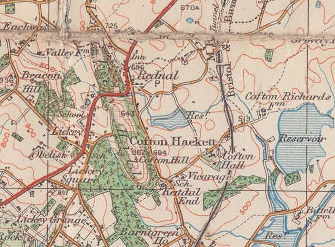
For 19th-century Ordnance Survey maps of Birmingham go to British History Online.
Map below reproduced from Andrew Rowbottom’s website of Old Ordnance Survey maps Popular Edition, Birmingham 1921. Click the map to link to that website.