William Dargue A History of BIRMINGHAM Places & Placenames from A to Y
Kings Norton
- one of the Domesday manors of Birmingham
B38 - Grid reference SP049789
Nortune: first record in the Domesday Book 1086, Northtone Regis 1286, Kynges Norton 1288

Kings Norton/ King's Norton is a classic village centre with its church, timber-framed manor house and pub focussed around a green. The village developed here during the Middle Ages, possibly on the site of the Anglo-Saxon settlement, with open strip fields surrounding the village. Although their precise locations are unknown, evidence of medieval ridge and furrow is visible in Kings Norton Park and on Kings Norton Playing Fields.
Nortune, from the Old English nord tun, 'north farm' or village was the northernmost of the berewicks, or outlying manors of Bromsgrove in Worcestershire.
Norton is a common name, there are at least three other villages so-named in Worcestershire. This royal manor was known as Kings Norton from the 13th century presumably to distinguish it from the others.
The Bromsgrove manors were originally Saxon estates in the Kingdom of the Hwicce and included Moseley, Lindsworth, Wythall, Houndsfield, Tessall and Rednal. Before 1066 these manors with many
others in Birmingham had belonged to Earl Edwin, the Anglo-Saxon Lord of Mercia. When in that year a Viking army sailed up the River Humber to invade England, Edwin went to do battle, but was
heavily defeated at the Battle of Fulford Bridge near York. King Harald arrived the next day, and after defeating the Vikings at the Battle of Stamford Bridge, immediately marched back south to
be himself defeated at the Battle of Hastings. Edwin and his broken remnant of an army were unable go with him.

Thus, after the Battle of Hastings, when William punished Harald's supporters, Edwin was not amongst them and did not forfeit his lands. Two years later, however, Edwin revolted against William who confiscated his holdings to give as rewards to his followers. Bromsgrove and its berewicks he kept, with himself both as tenant-in-chief and manorial lord. Thus the manor became Kings Norton remained royal from Domesday until 1804.
King's Norton, a parish and town in the upper division of the hundred of Halfshire, county Worcester, 5 miles South by West of Birmingham. The parish includes the town of its own name, and
the chapelries of Moseley and Wythall. It received the grant of a market from James I., but this has for many years been discontinued. Some of the inhabitants are employed in the manufacture of
nails.
An Act was passed in 1840 for establishing a court of requests here. Norton is also the head of a Poor-law Union, comprising five parishes, of which three, viz: Beoley, King's Norton, and
Northfield, are in Worcestershire, Harborne in Staffordshire, and Edgbaston in Warwickshire.
The church, dedicated to St. Nicholas, is a spacious structure, rebuilt in 1750 for £20,000, defrayed by Mrs. Fobrey. It has a tower, surmounted by a lofty spire, which has been twice shattered
by lightning, first in February, 1843, and again on the 13th May, 1850. There is a free grammar school, endowed by Edward VI., with about £15 per annum. Fairs are held on the 25th April and 5th
September.
The National Gazetteer of Great Britain and Ireland 1868 Edited

Well worth a visit - St Nicolas, the ancient parish church of Kings Norton. The Norman church here was originally established as a chapel of Bromsgrove and it was only in 1846 that the parish of Kings Norton was formally created.
Set in the north wall of the chancel are two of the original Norman windows which are over nine hundred years old. The small 11th-century church, which stood on the site of the present chancel, was rebuilt in late 13th- and again in the 14th century of local sandstone. The tower with its embattled parapet and fine octagonal crocketed spire, the south porch and doorway are 15th-century.
These developments testify to a prospering local community here during the Middle Ages probably rearing sheep and profiting by trading in wool. In 1615 the church roof was raised by the addition of a clerestory and the unusual gabled roofs. The chancel arch with its ballflower ornament is 14th-century but the chancel as it now appears dates from the restoration which was carried out in 1863.
Major restoration which was undertaken in 1872 to regothicise the church included the removal of the 18th-century box pews and low ceilings. The present appearance of the church dates from this
time. There are a number of good memorials here. Inside the church a worn slab commemorates the chantry priest Humfrey Toye who died in 1515. The splendid Greaves tomb with effigies of Sir
Richard and Lady Anne was originally in the chancel but was moved under the tower during the 1872 restoration. In the churchyard is the monument of the Middlemores, a family long associated with
the manor.

This church is noted for its good ring of ten bells. Bells were first hung in the tower when it was built in the mid-15th century. In 1783 the existing six were replaced by a ring of eight. One of the earlier bells dated 1689 still stands at the back of the church. The bells were recast in 1926 by Taylor's of Loughborough and two more were added to make the present ring of ten. St Nicolas' is one of Birmingham's many fine churches and has a Grade I Listing.
John Leland was Henry VIII's antiquary. His prime duty was to report on collections of books and manuscripts around the country. However, while on his travels he wrote a commentary on the places
he visited. In 1538 Leland rode from Alvechurch to Kings Norton, through Birmingham and on to Lichfield. He wrote:
Northeton is a praty uplandyshe towne in Warwike-shire [actually in Worcestershire], and there be some faire howsys in it of staplears, that use to by wolle [wool merchants]. There is a faire churche and a goodly piramis of stone over the bell frame. There rennithe a litle brooke [the River Rea] at the est end of the towne. Good plenty of wood and pasture and meatly good corne betwixt Alchirch [Alvechurch], and Northton. And lykewise betwixt Northton and Bremischam [Birmingham] that be distaunt from othar 5.miles.

Leland must have ridden by the Old Grammar School, which still stands in the churchyard. This Scheduled Ancient Monument is a fascinating building which raises some unanswered questions. The early 15th-century timber-framed upper storey is the older than the ground floor which was built in brick in the early 17th-century.
But the oldest part of the building is an unusual gothic window with wooden tracery at the east end whose origin is unknown. The school may have been built as the priest's house, or as a church meeting room; equally it could have been a guild hall and/ or a chantry chapel.
Chantry chapels were private chapels, often but not always within a church, bequeathed for the celebration of masses for the soul of the founder and his family. Some chantry chapels were paid for by trade guilds for their members.
It is known that in 1344 Edward III agreed to William Paas's request to support a chantry of the Virgin Mary at Kings Norton church. This building and the school possibly date from this time.
In Henry VIII's reign Henry Saunders was paid a £10 annual stipend as schoolmaster here. He taught 120 pupils in this small building, among them a local nailer's son, Robert Avenon who
subsequently walked to London to make his fortune. He prospered, became the Lord Mayor of London and was knighted by Queen Elizabeth I.
The Grammar School became a National school but was closed in 1875 due to inadequate accommodation. The inspectors were concerned about the suitability of the church burial ground as the
children's playground. Pupils were housed temporarily in the former workhouse on the Green until the new Kings Norton Village Board School opened on Pershore Road South in 1878. In 1914 the
grammar school building was given to St Nicolas' Church. It was restored in 2008.

Well worth a visit, Kings Norton Green, now at the heart of a conservation area which was designated in 1969. Its preservation is due to the creation of the Pershore Turnpike, a new route made from Birmingham in 1825. The old road had crossed the River Rea by a ford west of the present Pershore Road bridge, then headed directly up towards the church where it made a dog's-leg along the present Rectors Drive, past the Old Grammar School, into Back Road and onto the village green.
The new toll road avoided the narrow lanes and by-passed the old village centre, which was thus incidentally preserved. Since the 16th century the Green has been the site of Kings Norton Mop Fair
held on the first Monday of October. Originally a hiring fair, it attracted a variety of stalls and entertainments some of which still continue. There was also a regular cattle market here until
the 19th century.
Some medieval buildings survive on the Green. The former Hirons' Bakery (until c1990), now a general grocery store, is a late 15th-century timber-framed house. Its close-studded timber frontage
was revealed when a later brick façade was removed in the late 1990s. Excavation has also revealed post holes and beam trenches of other medieval buildings nearby, the houses of the wealthy wool
merchants mentioned by Leland.

Well worth a look, the Saracens Head.
Adjacent to the churchyard this was the bailiff's house and manorial court and may stand on the site of an earlier manor house. Substantially extended in the 16th century, the oldest part dates back to 1450. The building was used as an inn from at least the 18th century when most of the windows were altered. In the late 19th century the south wing was rebuilt for use as a parish hall. In 1930 the building was given by the brewery to the church in 1930 for use as parish offices and meeting rooms. The building was extensively restored from 2006-2008 and renamed Saint Nicolas' Place.
West of the Pershore Road South on the River Rea stood the manorial corn mill known as Hurst Mill. This is first recorded in 1221 held by Roger Clarke. In 1625 the mill was
jointly owned by Thomas Whorwood and George Guest, the Guest family retaining ownership until the 18th century. The last mill building was built in 1860, its last owner being Thomas Priest from
1920 to 1930. This was probably the last watermill in Birmingham to grind corn. After 1930 the mill pond was filled in to make way for river and road improvements and all the mill buildings were
demolished.
The Battle of Kings Norton Green which took place on 17 October 1642 was one of many skirmishes of the Civil War. The King's nephew, Prince Rupert left Shrewsbury to scout the
west Midlands prior to the royalist advance on London. After leaving Stourbridge he was at ease with eight troops of cavalry and three hundred footsoldiers on Kings Norton Green, when he was
surprised by Lord Willoughby of Parham. The latter with a parliamentary force of eight hundred cavalry and footsoldiers were on their way to join the Earl of Essex at Worcester. The royalists
were routed with fifty killed and prisoners taken; twenty parliamentary troops were killed. The dead lie buried together in Kings Norton churchyard in an unmarked grave. Rupert, pursued by
Willoughby, retreated towards Meriden to rejoin the King en route to London. The following report was read out in the House of Commons the next day:
A true Relation of a Great and Cruell Battell fought by the Lord Willoughby of Parham:
It is . . . informed by divers Letters from Brumegum, that the Lord Willoughby of Parham with about 800 horse and foot in his march towards the Lord Generall, met Prince Robert with 8 Troops of
horse and about 300 Foot, two or three miles from Brumegum, and gave him battle which was very fierce and cruell on either side, but at length the Princes souldiers retreated and fled, there
being slain of the Malignants about 50 and 20 taken prisoners, and of the Lord Willoughbies side about 17.
The royalists never did reach London. One week later they were prevented by Lord Essex at the Battle of Edgehill in the first major engagement of the Civil War.
Queen Henrietta Maria, the French wife of Charles I, was lord of Kings Norton manor. The following year she returned from Holland, having sold the royal jewels to help to pay for the war. After
landing at Bridlington, she came via Lichfield and Walsall to Kings Norton en route to the King's headquarters at Oxford. She arrived here on 10 July 1643 with 3000 horsemen, 30 companies of foot
soldiers, a train of artillery and an accompanying baggage train. Officers were billeted with local people while the troops camped by the River Rea, on the green and in the surrounding fields,
hence the name Camp Lane. The Queen slept that night in her bailiff's house, the Saracens Head in the room, which is now known as the Queen's Room, before setting off for Oxford the next morning.

The Worcester & Birmingham Canal built in 1815 leaves for Worcester at Gas Street Basin at the junction with the Birmingham Main Line). The route is 48km long (30 miles) via 58 locks including the UK's longest lock flight at Tardebigge, a descent of 40 locks giving access to the River Severn at Diglis Basin in Worcester.
The canal was 23 years in the building, and eventually took coal and industrial products south and brought grain, farm produce and building materials into Birmingham. Unusually pairs of donkeys rather than a single horse were used to tow the narrow boats on this canal. It has been suggested that, as the Waseley Tunnel had no towpath, the donkeys, being small, could be carried on the boats through the tunnel.
An important cargo on this line was not only coal, but also salt from Droitwich and from Stoke Prior from the 1830s. From the late 1800s Cadburys used the canal to bring the ingredients for chocolate-making to their wharf at Bournville.
At Kings Norton playing fields is the Kings Norton Junction with the Stratford Canal where Junction House/ Canal House of 1796 stands. This Grade II Listed building was the first office of the Birmingham & Worcester Canal Company and doubled as a toll house.
The Stratford-upon-Avon Canal of 1816 leaves the Worcester & Birmingham Canal at this junction and travels 41km via 56 locks to Stratford. The section from Kings Norton to
Hockley Heath was the first to open in 1796. The canal was financed by Stratford businesses, but probably benefited Birmingham more than it did Stratford. With railway competition the use of the
canal declined and it was not maintained, the southern section becoming almost unnavigable after World War 2. The Stratford on Avon Canal Society was founded in 1958 and it is thanks to their
efforts that the canal was restored and reopened by the Queen Mother on 11 July 1964.
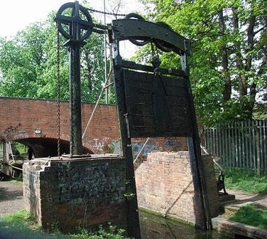
The unusual Lifford Guillotine Lock was a stop lock designed to stop water flowing either way from the Worcester & Birmingham Canal to the Stratford Canal; water was an expensive commodity for canal companies. The 15cm difference in water levels was maintained for over a hundred years until the whole canal system was nationalised in 1948.
The lock is brick-lined and the gate framework is of cast-iron. The gates are operated by a hand-winched counterweighted chain mechanism. The present gates are probably 19th-century but all other parts are original. The lock is Grade II Listed and Scheduled Ancient Monument.
Balsall Heath was the manor's most northerly district. It had developed as a Birmingham suburb from the mid-19th century and voted to amalgamate with the
City in 1891. Kings Heath and Stirchley saw major urbanisation during the second half of the 19th century, and by 1888 there had been some small local expansion at Kings Norton. However, at the
beginning of the 20th century the village was still rural and surrounded by agricultural land.

On the Pershore Road near the Green, Kings Norton Board School was built by William Hale and opened in 1878. The building was improved and extended in 1901 by Edward Holmes. The terracotta details date from this time. Also added were the Schoolmaster's House and the offices of the Kings Norton School Board, and four years later Kings Norton Library was built.
The people of the manor Kings Norton voted to amalgamate with Birmingham and, with the exception of Wythall. became part of the City under the Greater Birmingham Act of 1911. The ancient village
maintained its role as a focus for the area and remained rural until after the First World War when private housing development began west and east of the old village centre.
Broadmeadow, Druids Heath, Hawkesley and Walkers Heath, areas to the south of the
old manor were part of extensive municipal housing developments after the Second World War.
Click to enlarge the images in the Kings Norton Gallery below.


William Dargue 29.03.09/ 01.08.2010
For 19th-century Ordnance Survey maps of Birmingham go to British History Online.
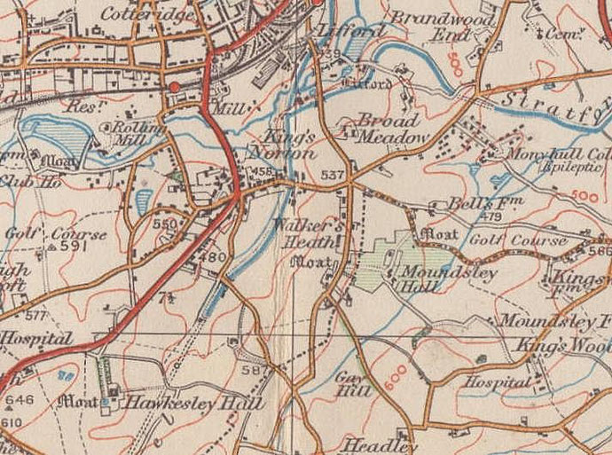
Map below reproduced from Andrew Rowbottom’s website of Old Ordnance Survey maps Popular Edition, Birmingham 1921. Click the map to link to that website.