William Dargue A History of BIRMINGHAM Places & Placenames from A to Y
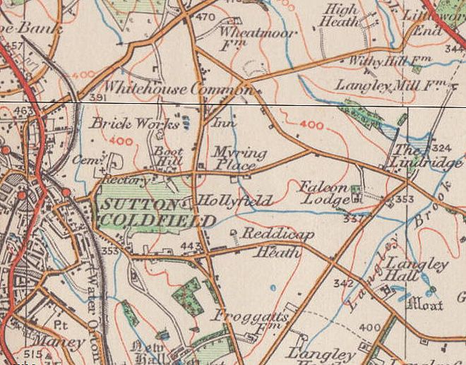
Falcon Lodge
B75 - Grid reference SP143962
First record c1820
Falcon Lodge is a council estate on the east side of Sutton Coldfield. It takes its name from a late-Georgian house which stood west of the junction of Wyatt Road and Langley Hall Road. Much of Wyatt Road marks the line of the drive to the house from Lindridge Road. Langley Hall Road was the drive from the house to Springfield Road.
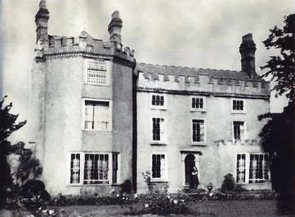
Built in 1820 in a neo-classical style on land recently enclosed, this crenellated 9-bedroom country house had extensive outbuildings and grounds and over 20ha of arable and pasture.
On the 1889 Ordnance Survey map can be seen the large orchard immediately north of the house. The first tenants were the Pepper family of Nottingham.
The origin of the name of the house name is unknown. It may well be a romantic 19th-century creation by the builder or the first residents.

Sutton Coldfield Corporation bought the house and some 20 hectares of farmland and orchard in 1937, but it was not until after the end of World War 2 that a municipal housing estate was built here.
Built in 1950s, the estate was considered a model development. It is spaciously laid out and has a community hall, library and shopping centre on Churchill Road to provide a 'village centre' focus as well as an allotment site and recreation grounds.
Construction began in the mid 1950s and progressed through the 1960s, covering a substantial area of former farmland in the east of Sutton Coldfield. Churchill Road follows the valley
of Churchill Brook. This flows down to join Langley Brook, which then runs north to join the River Tame near Middleton.
The majority of the buildings are terraced housing with some semi-detached. There is also a heavy presence of 3 storey flats around the centre of Falcon Lodge, with a total of 30 maisonettes. The estate had a tower block at its centre close to the row of shops called Brook House, but has since been replaced by modern houses. It was demolished in the 1990s due to social problems.

The tower's proximity to the Brook stream that runs through the centre of the estate ultimately led to severe subsidence and flooding in the tower block and tenants being forced to move. The towers were left derelict for a number of years while youths often entertained themselves in and around the premises.
In the early-mid 1990s the tower block was finally cleared along with a nearby school. Extensive work was also carried out on the Brook as undergrowth had grown out of control along with fly tipping. A new footpath leads throught the Brook now and the stream is cleaner.
Three other tower blocks similar to Brook House or The Mount high-rises in Reddicap Heath were constructed in the south of the estate on Stephen's Road. This is next to where the newer Berryfields Estate would be constructed in the 1980s with its 2 new wide red brick tower blocks.

The three tower blocks on Stephens Road began to fall into disrepair and by the end of the 1990s were pulled down as the newer Berryfields Estate provided fresh accommodation.
The estate has a local shopping centre called Churchill Parade and is also a terminus for buses running in the area. The shops are mainly independent and are located on only one side of the road in a 4 storey building with flats above them, whereas the buses terminate across the road where Brook House used to stand. Together with The Mount and Berryfields Estate, Falcon Lodge is part of the 3 estates forming a triangle around Reddicap Heath.
(Acknowledgements: text above, 7 paragraphs, from UK Housing Wiki.)
William Dargue 01.08.2010
For 19th-century Ordnance Survey maps of Birmingham go to British History Online.
Map below reproduced from Andrew Rowbottom’s website of Old Ordnance Survey maps Popular Edition, Birmingham 1921. Click the map to link to that website.