

William Dargue A History of BIRMINGHAM Places & Placenames from A to Y
Castle Vale
B35 - Grid reference SP144913
First record c1965

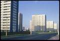
Known locally as The Vale, this 1960s housing estate with its central double column of tower blocks, its neglected houses and its late 20th-century reputation as a sink estate has been dramatically transformed at the close of the last and beginning of the present century.
The district's origins lie on the medieval manor of Berwood which lay north of the River Tame and east of the Chester Road. Used by late Victorian industry on its northern fringe and the site of an early sewage farm near the river, it remained rural until the 20th century.
Castle Bromwich Airfield
From 1909 some one hundred hectares were in use as Berwood recreation ground. With the outbreak of World War 1 the War Department set up Castle Bromwich Airfield 1915 to train pilots, and later to test planes, the first squadron here being the Royal Flying Corps No.10 Squadron. The airfield was not actually in Castle Bromwich but in Berwood; the River Tame south of here marks the boundary.

After the war the airfield was used by the Midland Aero Club and Birmingham University. In 1922 the aircraft hangars were let to the British Industries Fair BIF, an annual exhibition of Birmingham and national manufacturing. Close to the railway and the BIF, the airfield was considered for Birmingham's municipal airport. However, in 1933 Elmdon was chosen in preference. The flying field continued in use, staging the immensely popular Birmingham Air Pageants from 1927.
In 1925 land was bought by the Air Ministry as RAF 605 Squadron base, with more added in 1940 for use in World War 2. Aircraft built at Vickers across the Chester Road (now the Jaguar factory)
were tested here; over 11 000 Spitfires flying some 37 000 test flights. The airfield continued in use as a training facility until its closure in 1958.
St Mary's Church was built at Berwood to serve the RAF base and dedicated in 1923, and was destroyed by fire three years later. It was rebuilt shortly afterwards, but was later closed.

Post-war housing estate
Because of bomb damage and slum clearance priorities, in 1948 there were over 65 000 names on the housing waiting list. For twenty years after the war the building of houses remained a national priority, and large estates such as Shard End were built on the edges of the city.
However, as inner-city demolition continued, housing needs were still not being met. In the early 1960s plans were drawn up for Castle Bromwich Airfield Estate: one to house 22,000 people in 5000 dwellings almost half of them in 34 tower blocks laid in two lines along the centre of the estate. The estate was named Castle Vale with reference to Castle Bromwich by a schoolgirl in a competition early in the estate's development. The project was complete by 1970.
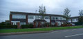
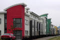
By the end of the 20th century, high-rise municipal housing had fallen out of favour and maintainance of the low-rise housing had been shamefully neglected. A housing trust took over the local authority's role as landlord and, with government funds, began to regenerate the estate.
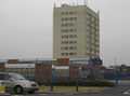
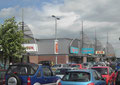
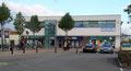
By 2000 only two tower blocks remained, many former council properties had been refurbished and a substantial number of houses were built for private sale. The shopping centre on the Chester Road side of the estate was completely redeveloped into a major retail park c2000.
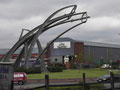
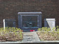
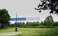
Click to enlarge the pictures in the Castle Vale Gallery below.
William Dargue 23.10.2008/ 01.08.2010
For 19th-century Ordnance Survey maps of Birmingham go to British History Online.
Map below reproduced from Andrew Rowbottom’s website of Old Ordnance Survey maps Popular Edition, Birmingham 1921. Click the map to link to that website.
